


1,175 meters high, 22 kilometers round trip. After reading the reviews, I gasped. But everyone told me that it wasn't that difficult to walk. With my usual skepticism and unwillingness to judge anything until I tried it myself, I had to go and see for myself how difficult Doi Luang Tak really was.
A trip to Doi Luang Tak in the middle of the rainy season, early August. After researching, I found out that this year it is only open to tourists on Saturdays and Sundays, with a limit of about one hundred tourists per week. Although I was a little disappointed because I prefer to travel on weekdays when there are fewer people, I had no choice but to accept this restriction.
We contacted the Huai Mae Kha Waterfall Forest Park, which manages tourism activities. We then gathered our members, booked bus tickets, packed our bags, and set off on our journey. No need for further ado.
(1)
The starting point for conquering Doi Langka is at Thung Kracho Municipality, Ban Tak District, Tak Province (note that it is Ban Tak District, not Mueang Tak District). Those who have a car can drive and park there. However, if you do not have a car, you can take a bus to Ban Tak or Tak Bus Terminal and then hire a car to get there by contacting the park officials.
Our nine-member team met at Tak Bus Terminal around 5:00 AM. After a short wait, an official pickup truck arrived to take us to Ban Tak District. On the way, we stopped at Ban Tak Municipal Market to buy food and fresh supplies. The market was quite good, with a wide variety of products available. There was also a 7-Eleven where we could buy any other necessities we needed.


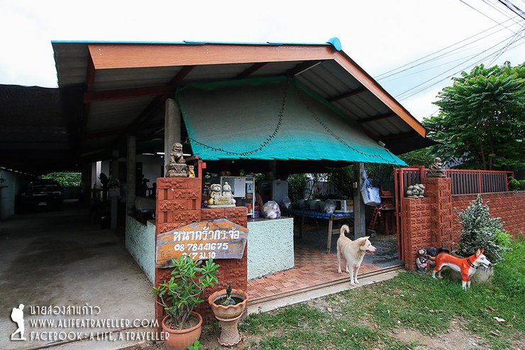
The car then dropped us off at a made-to-order restaurant opposite the Tung Kra Choe Subdistrict Municipality, which served as a gathering point. Breakfast was available, lunch was prepared for us to eat on the mountain, and dinner was sold when we came down. There were also bathrooms, showers, and storage for our belongings. It was a one-stop service.

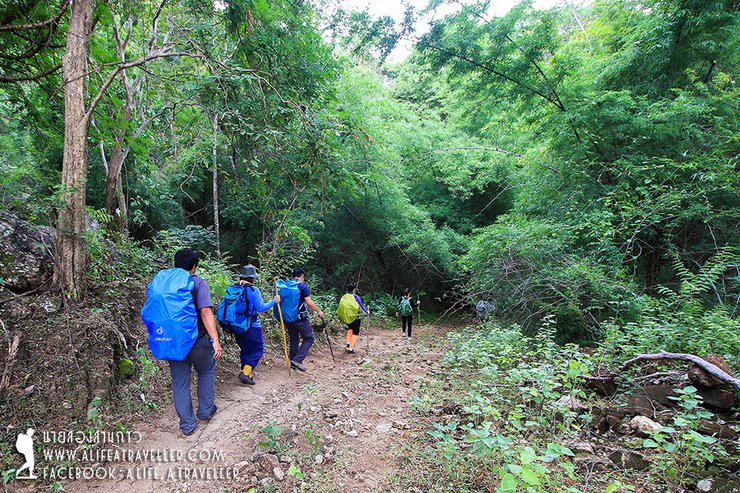
After eating, packing lunch, and dressing in full jungle gear, it's time to hit the trail. From the municipality, a ten-minute drive takes you to the starting point of the trail. The sign clearly states 11 kilometers. Checking the watch, it's 9:15 am.


The initial section of the trail is considered easy, with a relatively flat terrain that runs alongside a streambed that is completely dry. The lack of water was surprising, especially considering that it was the middle of the rainy season. Upon inquiring with the park rangers, we were informed that while it had been raining in other areas, this particular region had received very little rainfall.


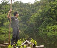
The group continued for a little over an hour before the path began to ascend, offering a refreshing view of the green forest. Taking the opportunity, they stopped to take some photos.


Hike at a leisurely pace, taking breaks as needed, as there is ample time. Around noon, take a break to eat and recharge at what I believe to be the steepest point of the trail. The climb is not excessively long. From this vantage point, one can admire the scenic views of the Huai Bua Klua Reservoir below and the Mon Mae Nang Phaya viewpoint above, which is located before reaching the summit of Doi Luang Tak.


Gazing at the expansive vista, I couldn't help but question the vastness of the forest before me. It seemed to stretch far beyond the boundaries of a mere forest park. Upon inquiring with the park officials, I discovered that Doi Luang Tak is not actually within the forest park's jurisdiction. Rather, it belongs to the Mae Tho National Forest Reserve. However, due to its proximity, the forest park manages tourism activities in the area. The future holds the possibility of merging three forest parks—Huai Mae Kha Waterfall, Kaeng Huai Tak, and Petrified Wood—with this section of the national forest reserve to establish a new national park.


Having gained knowledge, we continued our journey. After another hour of gradual ascent, we reached a clearing known as the Pine Terrace, offering a view of the nearby Doi Luang Tak summit.


From the pine forest, it takes only a short walk to reach this spot, Mon Mae Nang Phaya. The view is quite beautiful and you can walk around and take pictures freely. However, be careful not to fall, as it would be difficult for the staff to rescue you. (Haha...)


The final stretch involved a trek through a muddy banana grove, which was quite slippery. Upon exiting the grove, we reached our campsite at 2:25 PM. This was a leisurely hike with no need to rush, taking a total of five and a half hours. It was a comfortable journey overall.

Most campsites in the forest are occupied by porters who have set up long-term camps. Therefore, we need to find open areas near the forest edge. Those who want to hang hammocks should choose areas with more trees, while those who want to pitch tents will find it more convenient. The porters will collect water for drinking and use.


We hastily set up our camping tent, thinking that once finished, we would go up to admire the view on the mountaintop, which was just a short walk away. However, after we had arranged everything, white mist covered the entire area. The officer told us that they forgot to mention that we should have gone to see the view earlier, as the sky usually closes in near dusk.

Don't worry, nature is like this. Let's help each other cook and cook rice.


At night, the wind and rain were relentless, and many friends warned us that Doi Luang Tak Gloom was very windy. If the tent is not good, the tent is not set up well, or the hammock is not tied well, be prepared to sleep soaking wet.
(2)
I woke up around six in the morning, feeling groggy. The sound of rain pattering on the flysheet was a clear invitation to stay in bed. I dozed off again until after seven, but the rain continued. Back to sleep I went. Finally, at half past eight, the rain stopped. However, the air was thick with fog, reducing visibility to just a few tens of meters.


Unable to proceed, we gathered around, boiling water to make coffee and preparing fish and rice for breakfast. Many groups, especially those on organized tours, had to pack up and prepare to descend. As for us, we were relaxed, lounging and napping until almost ten o'clock.

After waiting for what seemed like an eternity, around eleven o'clock, hope finally emerged. The fog cleared slightly, revealing the peak of Doi Luang Tak. With renewed determination, we set off on foot, eager to see what awaited us at the summit.

The mist will come and go, revealing glimpses of the stunning mountain range that will make you smile. Seize the moment to capture these fleeting views, as the mist will soon return, shrouding the landscape in a white blanket once more.


Doi Luang Tak has two peaks, both of which are accessible to hikers. From the larger peak, there are trails leading to other scenic viewpoints. While a clear sky during the winter months would make for an enjoyable hike, the current weather conditions only allowed us to explore the smaller and larger peaks.


Around one in the afternoon, we decided to descend from the peak, satisfied with the refreshing experience. As we packed up our belongings at the campsite, the mist once again enveloped the mountaintop, turning it a brilliant white. We were the last group to leave, enjoying the solitude of the wilderness.

On the way back, we passed by Mon Mae Nang Phaya, secretly hoping that the sky might clear up so we could take some closing shots of the view. However, the opposite happened as fog rolled in along with a heavy downpour. We had to quickly descend the mountain instead.


After a while, the rain stopped. The ground below was as dry as when we ascended, as if it had never rained. It was strange that it had rained on the mountain but not here, leaving the area parched and arid.
The descent was relentless, with no time to rest. We stomped and stomped, feeling the distance for the first time. Even though it was flat, it felt like we would never reach the end. We arrived at the entrance around 4:30 pm, the whole gang complete. We took a car to eat and shower at the same shop before the staff dropped us off at the Tak bus terminal. We said our goodbyes and boarded our buses, heading home in the early evening.

In summary, I believe Doi Luang Tak is a suitable hiking trail for beginners. Although the distance is long (talking to the officials, it seems that it is not actually 11 kilometers), the path is not difficult, there are not many steep sections, and there are not many obstacles. Importantly, the officials are very attentive. However, those who want to start this type of trip should still be physically fit and prepare themselves before going. As for experienced hikers, there is no need to worry. This place is probably just a good place to go for a walk to avoid boredom rather than staying at home (lol...).
Doi Luang Tak is open to visitors until February. After that, it will be closed to avoid forest fire smoke and water supply problems. It will reopen in July when the rainy season begins.
While not the most challenging or demanding trail, it's worth a visit at least once. Trust me.
Information
- Open from July to February
- This year, climbing is only permitted on Saturdays and Sundays.
- Reservations are required with the Forest Park at 0895663202 before visiting.
- A guide is required; independent hiking is not permitted.
- Leeches may be encountered at the campsite during the rainy season, but not in large numbers.
- Transportation: Private vehicles can be parked within Thung Kracho Municipality.
- Public transportation: Take a bus to Ban Tak District (or Tak Bus Terminal, but it's further away) and arrange for a park ranger to pick you up (fees apply).
Expenses
- Guide fee (1 person) 1,200 baht
- Porter fee (1 person) 1,200 baht
- Roundtrip transportation fee from Thung Kracho Municipality 600 baht
- Roundtrip transportation fee starting from Tak Bus Terminal 1,800 baht
Follow my travel adventures on another channel.
The provided text is a hyperlink to a Facebook page. Here is the translation:
Facebook page of A Life A Traveller


นายสองสามก้าว / A Life, A Traveller
Wednesday, October 9, 2024 6:02 PM