


How to book and when to book? These are the most frequently asked questions when I am about to embark on the Mo Ko Chu trek, an epic hiking adventure in Thailand that is notoriously difficult to book. To be honest, I wouldn't have been able to book it myself. It was only by chance that a member of a group of friends who had already booked the trek had to withdraw, and I was lucky enough to take their place. Sometimes, good fortune comes easily.
For those unfamiliar with the challenges of trekking in Thailand, the Mogokju Trail in Mae Wong National Park, Kamphaeng Phet Province, is notoriously difficult to secure permits for. This is due to the limited access granted to the public, with only four months of the year (November to February) open for exploration. The trek itself is a five-day, four-night expedition, commencing on Saturdays and concluding on Wednesdays each week. Furthermore, the number of participants is strictly controlled, with a maximum of two groups of twelve individuals permitted per week. Consequently, only a fortunate few hundred individuals have the opportunity to experience the wonders of the Mogokju forest during the tourist season.
The competition to secure a reservation was fierce, with many experiencing great difficulty.

A five-day, four-night trek covering a distance of 29 kilometers one way and 29 kilometers back, with an additional short distance for a detour to a waterfall, totaling over 60 kilometers. This is the longest and most time-consuming officially managed and open hiking trail in the country.
This is the schedule for the next steps.
Day 1:
Starting point: 16 km (mostly flat, red dirt road) Destination: Mae Krasa Camp
Day-by-Day Itinerary:
Day 2:
- Camp Mae Krasa to Camp Mae Rewa (4 km, mostly flat terrain through bamboo forest)
- Visit Mae Rewa Waterfall and return to camp
Day 3:
- Camp Mae Rewa to Camp Tin Doi (8 km, steep ascent to Sib Ka Khao)
- Hike to the summit of Mo Ko Chu and return (1 km)
Day 4:
- Hike to the summit of Mo Ko Chu and return (1 km)
- Descend to Camp Mae Rewa (8 km, steep descent to Khao Phang)
- Return to Camp Mae Krasa (4 km)
Day 5:
- Camp Mae Krasa to Park Headquarters (16 km, red dirt road)
This trip, for the convenience of our group, we chose to travel by a rented van, leaving Bangkok on Friday night and returning to Bangkok on Wednesday evening. Valentine's Day, February 14th, is a good time to conquer this 1,964-meter-high mountain above sea level, isn't it?
Day 1: Office > Mae Krasa
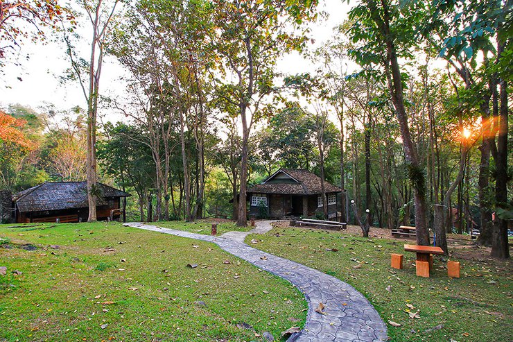
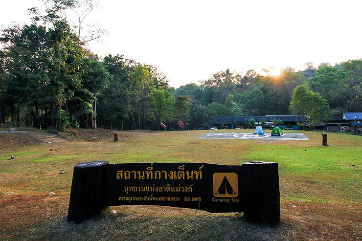
We departed from Bangkok by van around 10:45 PM and arrived at the Mae Wong National Park headquarters around 3:30 AM. We found a simple place to sleep at the tourist service center. At dawn, we woke up instinctively, even though we hadn't gotten much sleep. The morning atmosphere in the park was excellent, very refreshing. If you have free time, spending a night or two here would be delightful.


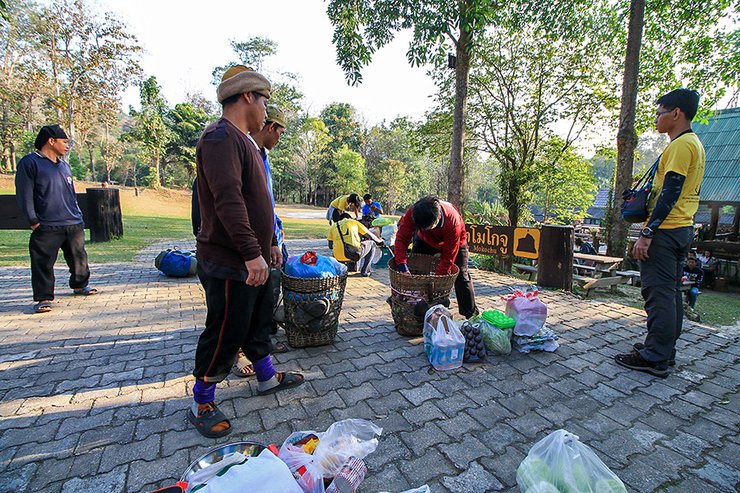
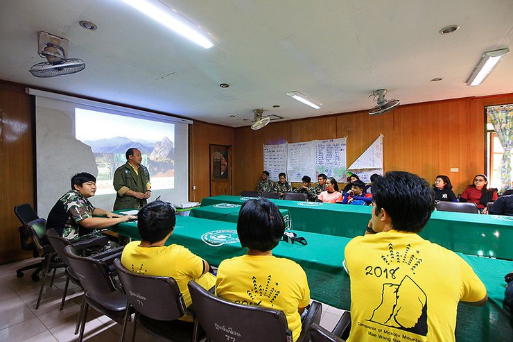
We packed our belongings and ate at the welfare shop. Before starting the hike, we had to register, settle various expenses, and most importantly, listen to a briefing from the park officials about the trail, regulations, facilities provided by the park, and what we needed to bring ourselves. The briefing was delivered in a humorous manner, keeping the atmosphere light.
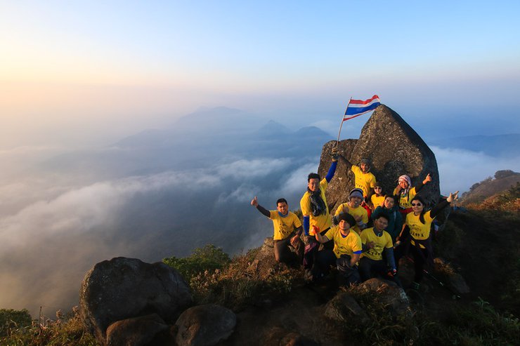
“The supervisor instructed me to inform you that climbing on the sailboat rock is prohibited. Okay, I will convey the message. Consider it delivered,” the officer smiled. He then proceeded to show a series of stunning photos of Mo Ko Ju featuring individuals posing on the sailboat rock. He concluded by requesting that visitors who capture captivating images share them with the park for promotional purposes. (laughter...)


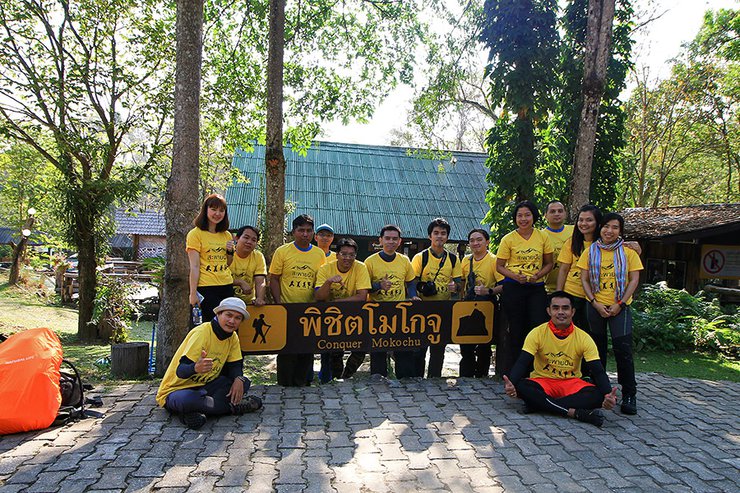
Having learned everything they needed to know, they took a souvenir photo in front of the sign. Of course, it was a handsome and beautiful picture, the last one of their trip.

Both groups walked together, accompanied by four staff members. Our group had three porters, each carrying 20 kilograms. However, because the cooks had prepared a slightly luxurious meal, the weight exceeded the limit. It was the men's responsibility to share the burden and make the load a bit heavier.

Glancing at the clock, it's 10:05 AM, time to hit the road. The starting point for conquering Mo Ko Chu is at the large sign for Mae Wong National Park, near the park headquarters. We're ready, let's go!

The 16 km trail from the office to the first Mae Krasa camp is a red clay gravel road. It is a real road that officers regularly use four-wheel drive vehicles and motorcycles to access when they need to perform their duties.


According to the park rangers, the park had initially planned to allow visitors to take a vehicle directly to Mae Krasa this year to shorten the trekking distance and the number of days required for the trip. However, heavy rains shortly before the park's opening caused damage to the road, forcing the plan to be temporarily shelved. The possibility of using vehicles to reach Mae Krasa may be reconsidered for next year.
After a smooth two kilometers, you will reach the first steep slope called "Mo Khee Taek". The incline isn't too bad, but as it's the first slope after a long, one-kilometer stretch, it can feel a bit brutal (haha...).

After the first steep hill, the trail becomes relatively flat with occasional gentle slopes. The hike continues under the sun, with opportunities to rest. The trail crosses the Huai Manao stream several times, providing opportunities to refill water bottles for those with portable water filters.


The group started to disperse as we continued walking. Those who walked faster moved ahead, while those who walked slower lagged behind. I didn't rush and stayed in the middle of the pack. At 2:30 pm, we reached the 11/29 kilometer marker. The first number indicates that we have walked 11 kilometers, and the second number indicates the distance to the top of Mount Mogoku. However, we will be walking 16 kilometers today, so we have 5 kilometers left.

After walking for 11 kilometers, only five kilometers left may seem like a short distance. However, for me, Mogochu is a deceptive forest. When it says there is only a little left, why doesn't it arrive? (Wa)
As the sound of water grew louder, it became clear that the Maekasa Camp was close. However, despite passing numerous bends in the path, the camp remained elusive. Exhausted, the speaker decided to rest before continuing, accepting that their arrival time was uncertain.


At 4:10 PM, a sight that brought smiles to everyone's faces emerged: Camp Mae Krasa. The first thing everyone did was grab a Coke or Pepsi to quench their thirst after the long journey. Thankfully, the staff had thoughtfully chilled the drinks, which were available for only 15 baht each.


At the Mae Krasa Camp, the park has set up a well-maintained tent site with three pavilions for different groups. The central pavilion is for park rangers and porters, while the left and right pavilions are for different groups. There are also well-maintained toilets, which are for waste disposal only.


Bathing in the open air at Mae Krasae Stream is much more refreshing.

Fortunately, our group has a skilled cook, so we eat very well. Everything is well prepared, and we eat better than at home. (Haha...)

The sentence is already in English and does not require translation.

At Mae Krasae, there are three peacocks. The female is quite territorial, so be careful not to get too close when taking photos, as one of our group members was chased and pecked, drawing blood. As for the tame hornbill that used to be here, the staff informed us that it sadly passed away after being electrocuted at the forest fire control station.

In the early evening, the peddler gave us some wild lingzhi mushroom soup to drink. They had just picked it nearby. They said that it would help relieve pain and fatigue. I don't know if it's true or not, because our aches and pains are probably not going to disappear overnight. (Haha...)


The sentence is already in English and does not require translation.
After that, everyone relaxed as they pleased. Some people sat and chatted, while others took a nap, depending on their individual lifestyle.
Day 2: Mae Krasa > Mae Reua
Today is a rest day for the legs, with a total walking distance of only about 10 km and almost no steep slopes. The first 4 km is from the Mae Krasa Camp to the Mae Reua Camp, and then 3 km from the Mae Reua Camp to the Mae Reua Waterfall, and 3 km back.
The reason for the rest stop is because yesterday we walked a heavy sixteen kilometers, and it is also a rest for our legs to prepare for the brutal climb to the summit tomorrow. "If we walk sixteen kilometers and then climb to the summit the next day, I'm afraid the tourists will be crippled," the officer laughed.
The morning at Mae Krasa Camp was refreshing. We woke up, packed our belongings, cooked and ate breakfast, and prepared lunch. Around 9:00 AM, we shouldered our backpacks and started walking. Note that you can leave any unnecessary items at the camp, as you will return for your final night.

Today's path is almost entirely through a bamboo forest, which indicates that we are at a relatively constant altitude.


Around eleven o'clock, we arrived at the remains of the Karen people's houses, before the national park was declared and the villagers were relocated to other settlements. As you can see, without this type of management system, Mae Wong National Park would not have reached its current state of completeness.

From there, it's just a ten-minute walk to the second camp, located by the Mae Reua stream. The park has cleared a comfortable camping area for some, and there is a bamboo toilet shelter. If you need to relieve yourself, grab a bucket and collect water from the stream.


Take a break and have lunch for a while. At 1:30 PM, we will walk to Mae Rawa Waterfall without carrying any luggage. The distance is 3 km. It is a path through a bamboo forest. It is easy to walk, but the bamboo forest can be a bit confusing. If you are not following an officer, you must read the path carefully. Be careful not to get lost.


Within an hour, we arrived at Mae Rawa Waterfall. Without further ado, we all enjoyed playing in the water.


The sentence is already in English and does not require translation.
After playing in the water to their heart's content, they gradually returned to the camp around 3 pm. Upon arrival, they were treated to a delicious meal prepared by the camp's cook, which even included boiled mung beans. It was truly a delightful experience.


And as always, we got to drink lingzhi mushroom water from our lovely hawker again. I don't know if it really helps physically, but it definitely helps mentally. (Haha…)

The sentence is already in English and does not require translation.
Tonight, everyone went to bed early because tomorrow we will be walking all day. I chose to sleep in a hammock by the river, listening to the sound of the stream lulling me to sleep. It was incredibly peaceful.
Day 3: Mae Reua > Mokogju
Waking up early and feeling energized, as this is the day everyone has been waiting for. We eat breakfast, pack our belongings, and are ready to set off by seven in the morning. Similar to the Mae Krasa camp, we can leave any unnecessary items here.
The previous two days of our journey were relatively smooth, but today will be a completely different story. We will be ascending from an altitude of 300 meters above sea level to 1,900 meters within a distance of just 8 kilometers. This means that over 80% of the trail will be uphill, with any descents only leading to steeper climbs ahead.
No matter the cost, there's no turning back now.


One of the additional tasks assigned to our guides on this expedition was to install wildlife cameras on the trail leading to the summit. In addition to installation, they also need to replace the batteries and memory cards every fifteen days. This is the fifth camera they have installed since the last installation a month ago. If you think that forest rangers don't have much to do, think again.


Beads of sweat dripped down my face, countless in number. By ten o'clock, I had reached the first point, known as "Rope One," where a rope was provided to assist with the ascent.

Following a rope, one will reach a canal. A small stream originates from a spring, making it an excellent spot for resting and enjoying a meal. The forest's condition begins to change, becoming denser with more and taller trees.


A steep climb up a rope, across a canal, and then another rope, even steeper than the first. Just imagining the descent makes my legs tremble.

As we continue our ascent, we will soon reach a point where the summit of Mount Mogokju is within sight. This thought brings a sense of relief and joy. (Laughter...)

In fifteen minutes, we will reach Khlong Song, the final stream before ascending to the base camp at the foot of the mountain. Fill your water bottles as much as you can comfortably carry, but don't overdo it as the porters will take care of bringing enough water for us.

The short but incredibly steep climb from Khlong Song to the Doi Bok campsite takes about half an hour and requires several bursts of energy.


Upon reaching the camp, only one kilometer remains to the summit of Mount Mogokju. However, before proceeding, it is necessary to address the matter of sleeping arrangements and a designated area for gathering (eating). Tents are available, or hammocks can be used, depending on individual preferences.


The sentence is already in English and does not require translation.
Glancing at the watch, it was 3:40 PM. This marked the moment to embark on the final push to conquer Mount Mogochu, with the last kilometer remaining.

The sentence is already in English and does not require translation.
Emerging here, Mount Mogoku is right in front of us. Would you believe that this is the first time I've seen such a wide view since I started walking from the office? All the way here, we've been in the forest, so I had to take a picture.


Looking back from the first peak of Mount Mogokju, the view is equally stunning.

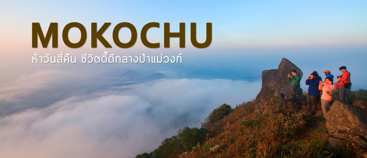
And finally, at 4:13 p.m., we reached the summit of Mo Ko Chu, a 1,964-meter-high mountain shaped like a sailboat. The atmosphere was gloomy and overcast, living up to the name Mo Ko Chu, which in the Karen language means "like rain is about to fall."
Regardless of the outcome, there is no greater joy than reaching this point. Take a deep breath and let it all go.


The summit of Mount Mogokju offers a moderate trail along the ridge, where we each took photos and reveled in the breathtaking scenery. Although the overcast sky prevented us from witnessing the sunset or the vibrant evening light, I believe the stunning divine light we encountered made it a worthwhile experience.


One of the things I love most about the summit of Mo Ko Chu is the 360-degree view of pristine wilderness. No houses, no buildings, just endless green forest as far as the eye can see. To the west lies the Huai Kha Khaeng Wildlife Sanctuary, to the east the Khlong Lan National Park, and to the north the Thung Yai Naresuan Wildlife Sanctuary. Together, they form a vast expanse of protected forest, making it clear why the Western Forest Complex is so deserving of conservation.

I took the last photo on Mogokju at 6:15.
The camp was pitch black when we arrived. Our friends, who had arrived earlier, had already prepared food for us, so we ate to our heart's content.
(Laughter…) When it was time to sleep, everyone went their separate ways and fell asleep almost immediately.


Day 4: Mogokju > Mae Krasa
I set my alarm for 4:30 am. I woke up and prepared my camera and equipment quickly. Then, I used a flashlight to walk to the top of the mountain. Some of my friends went to see the stars on the Sail Rock first, but I didn't go there. The image I wanted in my head was a distant view of Mount Mokoju, surrounded by stars and the Milky Way.
While not overly impressive (due to limitations in skill and equipment), it still brought a smile to my face.


As the sky began to brighten, I slowly walked to the top of Mokochu. I must confess that after the gloomy evening yesterday, I felt a sense of relief that the sky was clear and bright again today. After taking a few photos, what everyone had been dreaming of seeing began to take shape. White mist began to flow with the wind through the ravines in all directions.


Gradually, the mist gathered, transforming the barren landscape of Mo Ko Ju into a paradise. Words fail to capture the breathtaking beauty that unfolded before my eyes.


After enjoying the heavenly scenery until around eight o'clock, we descended from the peak. We packed up our camp and walked down, cherishing the memories of the breathtaking moments we had just experienced. Although it was only a short time, it was truly magnificent.
The scorching sun beat down mercilessly, making me silently thank the heavens that yesterday's overcast skies had spared us from such intense heat. Otherwise, the ascent would have been unbearable.


The descent was long and steep, and like everyone else, my legs were tired but not sore. The steeper it got, the more my knees ached. Each person developed their own unique walking style (laughs…). We finally reached Mae Reua Camp around two o'clock in the afternoon, rested for a while, and then continued walking to Mae Krasa Camp, where we would spend the night.


3:30 PM arrived at Maekasa. Yay… Scored one (lol…)

A local bird flew in to greet me. Although I didn't see any hornbills, I did encounter a wrinkled hornbill (the smallest hornbill species in Thailand), which was still a good thing.

The rest of the day was spent relaxing, eating, swimming, and soaking up the natural beauty of the surroundings.
Day 5: Maekasa > Office
The final day of the journey involved a grueling 16 km trek. The initial plan, as agreed upon with the officials, was to depart at 7 am to avoid the midday heat. However, a radio report of fresh elephant tracks and droppings along the return route forced a change in plans. To avoid an encounter with the elephants, the departure was delayed until 9 am.
I left the camp as the last group, walking along the red dirt road, overtaking some people and being overtaken by others. We sighed and laughed at each other, as is the way.


And here are the traces of the local big brother that made us have to go out on the road, huh? It's good to just find footprints, because if we meet him now, I don't think we'll have enough energy to run away in time (laughs…)

Shortly before two o'clock in the afternoon, we returned to the tourist service center, marking the end of our conquest of Mount Mogokju.

The sentence is already in English and does not require translation.

After a long hike, capturing memories in photographs, I deeply understand how important it is for us to protect this forest. It is a forest surrounded by forests, where traces of animals can be seen all along the way, both footprints and their droppings.
It would be difficult to find a more complete forest than the Western Forest Complex in Thailand.
The forest is currently closed, but we wish everyone the best of luck for the next opening. If you are lucky enough to secure a reservation, don't let the opportunity slip away.
The Untamed Wilderness of Mae Wong and Pa Ta Wan: A Glimpse into Pristine Forests
The lush forests of Mae Wong and Pa Ta Wan offer a profound understanding of what a truly pristine ecosystem entails. Here, nature reigns supreme, showcasing the breathtaking beauty and intricate balance of an untouched wilderness.
Before Embarking on the Majestic Mount Mogokju
Before venturing into the awe-inspiring heights of Mount Mogokju, it is essential to gain a deeper appreciation for the surrounding forests. These verdant landscapes serve as a testament to the power of nature, offering a glimpse into a world untouched by human intervention.
- Reservations for trips each year are accepted by the park via email only. Regulations are subject to change annually and are announced in October.
- The cost during the tourist season of 2017-2018 was 13,500 baht per group, with two park rangers as guides.
- Porters cost 550 baht per day per person, totaling 2,750 baht for a five-day trip. They carry 20 kilograms of luggage per person upon entering the park, with additional charges for exceeding this weight limit. However, they may carry slightly more during the trek.
- In addition to carrying luggage, porters at Mokoju assist with water management, rice cooking, fire building, and various other tasks.
- Sleeping arrangements at each camp are flexible, with options for hammocks or tents to suit individual preferences.
- Luggage can be stored at both Mae Krasa Camp and Mae Reua Camp to reduce weight during the trek, and collected upon returning as the return route follows the same path.
- Ticks and chiggers are the main insects to be wary of. While our group was not heavily affected, some members, including myself, were bitten. Those who are not allergic will recover quickly, but those with allergies should bring antihistamines and anti-itch medication. Wearing protective clothing is also recommended.
- Water sources are available daily, but it is essential to carry a portable water filter, with at least one per group.
- At Mokoju, there are streams for bathing every day except for the third day when camping at the foot of the mountain.
- The summit of Mokoju offers stunning views of both sunrise and sunset. It is highly recommended to ascend the peak during both times, as the challenging journey and limited reservations warrant maximizing the experience.
- Mobile phone signal is available only for AIS network users at Mokhi Taek, the final point of the first day's trek (a short distance from the start). Intermittent signal is available again during the ascent before reaching Klong Nung. Other areas have no signal, providing a complete disconnect from the outside world.
Follow my travel adventures on another channel.
http://www.facebook.com/alifeatraveller
นายสองสามก้าว / A Life, A Traveller
Wednesday, February 26, 2025 3:26 PM