


“Hipster Hill” is a nickname given to Mon Chong by a friend, probably because of its popularity among young people. Along with the rumors of its beauty, there were also rumors of its easy accessibility. When my friend said we had to visit this place, I immediately agreed. I wanted to see for myself if the rumors were true.
Mon Jong: A Mountain Paradise in Northern Thailand
Mon Jong, both a mountain peak and a sub-district in Omkoi District, Chiang Mai, offers a unique blend of natural beauty and cultural immersion. The forested area falls under the jurisdiction of the Omkoi Wildlife Sanctuary, where local communities collaborate with the sanctuary to manage tourism and generate income for residents.
The peak is open to visitors from November to mid-February each year. This seasonal closure is necessary due to increased wildlife activity, particularly wild elephants, seeking food on the summit.
To plan your visit, contact the Mon Jong Mountain Tourism Service Center at 092-559-7201 or visit their websites: www.doimonjong.com/monjong and www.facebook.com/doimonjong.omkoi.
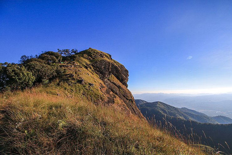
The highest peak of Doi Mon Jong, also known as Doi Huasingh, resembles a lion's head when viewed from afar. It stands at an altitude of 1,929 meters above sea level, making it one of the ten highest mountains in Thailand.

This trip took place in late December 2017. Eight of our nine members traveled by bus from Bangkok to Mae Sariang, arriving at the Bo Luang intersection in Hod district, the entrance to Omkoi district. We arranged for a four-wheel drive vehicle to pick us up there and take us to Doi Mon Jong. I traveled separately, as I had a longer itinerary that included renting a motorcycle to explore Chiang Mai during that time.

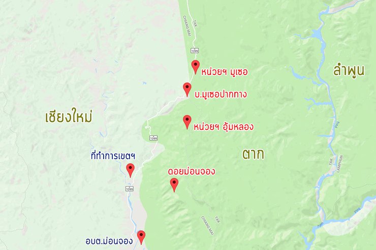
To clarify, the Doi Mon Jong Tourist Service Center is not located within the Mon Jong sub-district itself. In fact, it is almost forty kilometers away. If you are driving, it is more reliable to set the coordinates in Google Maps to "Doi Mon Jong Viewpoint". Additionally, if you are in the vicinity and the coordinates indicate the district as Sam Ngao, Tak Province, do not be alarmed. This is due to the border between the two provinces.
(1)
I traveled by motorcycle for three or four days from Chiang Mai, passing through Ob Khan National Park, Mae Wang National Park, and Ob Luang National Park in Hod District. I continued to Omkoi District, where my destination was the Mu Se Forest Protection Unit in the Omkoi Wildlife Sanctuary. The unit is responsible for ensuring the safety of tourists who climb Doi Mon Jong. The distance from Ob Luang is about 100 kilometers, which is a long ride.
By the time they dragged their weary bodies and motorbike to Muse, it was already dusk. The views along the road were undeniably stunning, prompting them to stop and take photos at regular intervals.


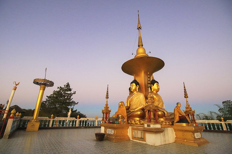
Upon arriving at Ban Musoe, one of the must-visit spots is the viewpoint of the Four Cardinal Directions Buddha statues. It serves as a gateway to Ban Musoe. This area is also where villagers sell their agricultural products and goods by the roadside during the day.

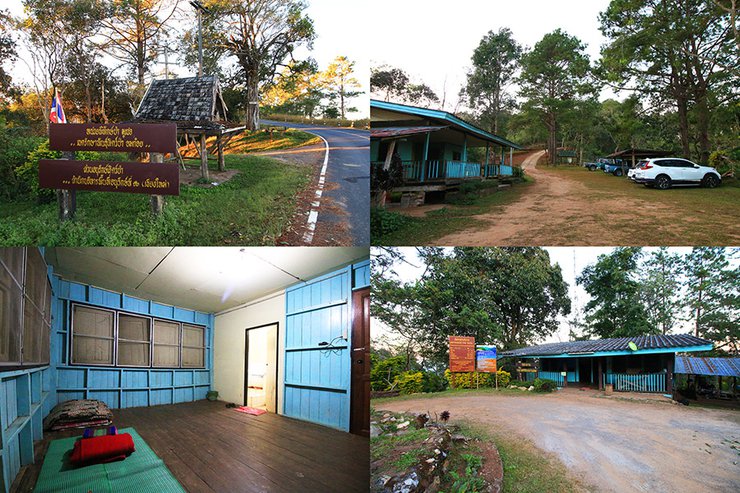
After taking photos to our heart's content, it was time to head to the Moo See Forest Protection Unit (located on the left, about one kilometer before the Four-Faced Buddha statue). With a big smile, we asked the officer if we could pitch our tent there as we were planning to climb Mon Jong the next day. The officer's response was, "Why would you want to camp out in the cold? Come and stay in the house instead. We have bathrooms, electricity, and we'll even provide you with mats, blankets, and pillows." We were truly touched by their hospitality. Thank you so much!

The scene cuts to the next morning. The alarm clock is set for 6:00 AM. As soon as I wake up, I rush to the car to watch the sunrise. The colors of the morning sky are truly beautiful in this cold season. The area where the sun rises is the Sam Ngao district in Tak province.

The sentence is already in English and does not require translation.

Around nine o'clock in the morning, I contacted my friend from Bangkok by phone and learned that he was about to arrive at the unit. Therefore, it was time for me to prepare myself.
(2)
At 9:30 AM, the Muser Kra Kra Forest Protection Unit was teeming with tourist vans and four-wheel drive pickup trucks. As soon as our friends arrived, they registered with the officials as required.
From this unit, the car will take us to the Doi Mon Jong Community Tourism Service Center at Ban Mu Ser Pak Khang. If you are driving yourself and need to contact a four-wheel drive vehicle and porter, you can do so here. As for us, everything is prepared, so we just need to register again.


The four-wheel drive vehicle took us to the Um Long Ranger Station, which is the actual entrance to Doi Mon Jong. Here, we had to pay an entrance fee: 20 baht for Thai citizens and 200 baht for foreigners. Camping fees were 50 baht per tent (based on the number of tents, not the number of people). As our group included four foreigners, we had to pay a bit more.

The sign at the Um Long checkpoint clearly states that the parking lot is 11 km away and Doi Huasing is 18 km away. This means that the walking distance from the starting point to Doi Huasing is 7 km (but only 5 km to the campsite). It's not too far, but it's not too short either.

The road from here is just red clay, so the back of the truck bounces and we eat dust as usual (laughs...). But the pine forests on both sides of the road are really green and refreshing.


It took about forty minutes for our heads to turn red as we arrived at the parking lot in the middle of the forest.
The parking lot was already filled with numerous vehicles, creating a lively atmosphere due to the weekend. It is estimated that the number of tourists visiting the mountain today could reach nearly two hundred people.

Navigating this trail does not require a guide, as the path is well-defined and local porters are present to assist and keep an eye on things. While the summit of Doi Huasing is nearly 2,000 meters high, there is no need to be concerned because the starting elevation for the hike is already a significant 1,500 meters.
Ready, set, go! The clock says ten minutes to ten. The first stretch of the walk starts with a small hill, just enough to get the blood pumping. Thankfully, it's not too steep.


However, after the first hill, we had to frown because it was a long, steep descent. This meant that on the way back, we would have to climb up again, which would make us breathless. I really don't like that feeling. Damn it (lol...)

The lush green scenery of Mon Chong Forest in late December was breathtaking. We ambled along, traversing a series of gentle slopes and open ridges that offered panoramic views. We paused at scenic spots to capture the beauty, savoring the leisurely pace of our exploration.


Around noon, we arrived at a place called Phuhin Chor, which offers stunning panoramic views. Reaching this point signifies that we have completed more than half of the journey.


After passing the rocky outcrop, the trail cuts into dense green forest once again. After walking for another hour or so, you will come across the "Dog's Panting Hill" sign. Looking up at the hill, you can't help but gulp. Not only is it steep, but it is also an open grassland that seems to challenge the sun.

The only challenging slope we had to overcome was the "Dog's Panting Hill." The difficulty stemmed not from the steepness or the heat, but rather from the loose, reddish soil that made the surface quite slippery. While the ascent was manageable, the descent was likely to be more daunting.


After climbing the steep slope of Khao Ma Hob, we were greeted with a breathtaking view. In the distance, Doi Huasingh stood majestically, its silhouette outlined against the horizon. The trail snaked along the ridge, inviting us to explore further. The sight was truly awe-inspiring.


From the Mahop Hill, it is not far to reach the point called the Elephant Golf Course (probably because it is open enough for elephants to play golf). This is like a three-way intersection. Going straight is the top of the Lion's Head, about 2 kilometers away, but we have to turn left and go down to the campsite near the forest first.


The clock ticked to two-five in the afternoon, marking exactly four hours since we left the parking lot. We had covered 5 kilometers at a leisurely pace. If we had pushed ourselves, we could have covered the distance much faster. Overall, the Mon Chong hiking trail lived up to its reputation as being relatively easy, especially compared to other mountain trails. It's a perfect option for beginners looking to try their hand at this type of adventure.
There are two campsites located about a hundred meters apart. You can choose to either hang a hammock or pitch a tent. Additionally, there is a source of clean water and a pit toilet available for emergencies. This makes it quite convenient for a hiking trip. There are also park rangers stationed here to ensure the safety of visitors.


We took care of the road arrangements and then set up a field kitchen to cook rice.

Around half past three in the afternoon, we started our trek to Doi Huasingh with only a bottle of water. The trail was only two kilometers long, so why did we start so early? The porter told us that even though the distance was short, it usually takes two hours to walk. Is it difficult? No, it's not. It's just that we walk slowly because we take photos along the way. (Haha...)
As I walked along the ridge towards Doi Huasingh, I realized why it was important to allow plenty of time. The trail was incredibly scenic, with stunning views at every turn. We stopped to take photos every few steps, capturing the beauty of the landscape.


Besides the stunning views from Doi Huasing, another highlight of Mon Chong is the abundance of thousand-year-old roses. Unfortunately, during our visit in late December, they were just starting to bloom. Had we visited a month later, the entire mountain would have been in full bloom.


We strolled along, taking pictures all the way.
The view is beautiful in all directions, both looking forward and looking back.

The sentence is already in English and does not require translation.

After a long trek, we finally reached the summit of Huai Singh at nearly five in the evening. The sign marking the highest point of Doi Mon Jong stood proudly, offering us a chance to capture the moment.

The sentence is already in English and does not require translation.
From this point, you can actually continue walking. The path will lead you to a small hill where a pagoda is enshrined. From there, you can reach Doi Huai Ling or Mon Chong Noi. However, our group decided to stop here as we were already satisfied with the beautiful scenery we had witnessed.

Looking westward from Doi Huasing, one can see the Mae Tuen stream and Mae Tuen village in Omkoi district. Crossing the distant mountains leads to Tha Song Yang district, Tak province. The complex mountain range to the east is the Mae Tuen Wildlife Sanctuary, also in Tak province's Sam Ngao district. This is because Omkoi is like a protrusion of Chiang Mai extending into Tak province. Looking at a map will immediately make this clear.
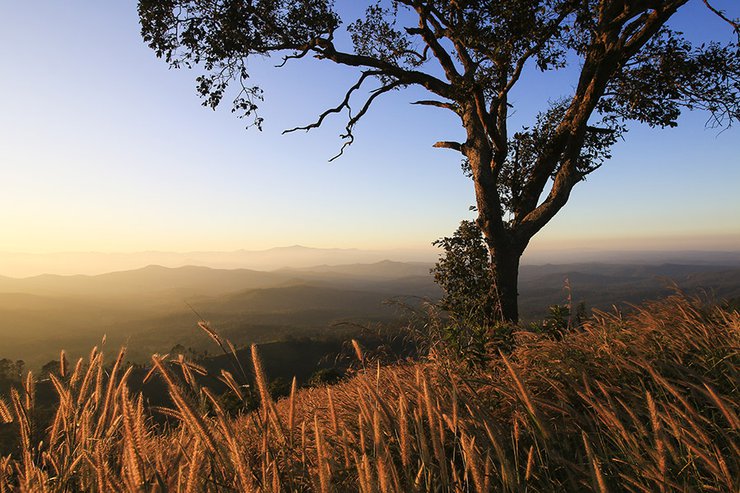
As dusk approaches, tourists are guided down from the Lion's Head for two reasons. Firstly, remaining at the summit until nightfall would make it difficult to descend. Secondly, returning at this time allows for a more spectacular view of the Lion's Head and the surrounding grasslands bathed in the golden light of the setting sun. This breathtaking spectacle has earned Mon Jong the nickname "Land of the Golden Grasslands."
As the time approached, we set off to find the perfect spot to admire the beauty of the golden meadow. It was truly breathtaking, living up to its reputation.


We arrived back at camp just before dusk. We helped each other cook and prepare more rice, having fun with our limited skills (haha...). Up here, everything tastes good. The deliciousness comes more from the atmosphere than the actual taste of the food.


Around eight o'clock in the evening, my friends and I went up to the Chang Golf Course to watch the stars and enjoy the cool breeze. It was truly a heartwarming experience.


(3)
At 4:30 a.m., the alarm clock jolted me awake. I quickly changed clothes, put on my shoes, grabbed my camera and tripod, and held a flashlight as I walked through the darkness with a large group of like-minded individuals to watch the sunrise. We had already scoped out the perfect spot the day before.
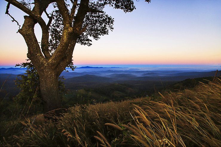
Before the sun rises, this is the reward for waking up early.

Some choose to hike to the peak of Lion's Head, while others opt to remain on the same slope as me, patiently waiting as the sky transforms from pitch black to navy blue, before being painted with hues of yellow, orange, and pink, as the dawn of a new day greets us with a smile.


I confess that a digital accident caused all my photos from today, since I woke up, to disappear from my memory card, irretrievably. Only a few low-quality files that I had previously posted on Facebook remain, as you can see here. (So sad...)
As the sun began to rise, we leisurely made our way back to camp. We enjoyed a leisurely breakfast, packed up our tents, and prepared our backpacks. By the time we set off on our return journey, we were nearly the last group to leave.
A four-wheel drive vehicle awaited us at the parking lot (the driver was sleeping nearby). We drove back through the dust on the same route and arrived at the Muse Forest Protection Unit around two in the afternoon. It was time to part ways with my friend and continue on my own journey for the next four or five days.
Despite being a short two-day and one-night trip, Doi Mon Jong lived up to its reputation for stunning scenery and relatively easy hiking trails.
Once upon a time, there was a lion sitting on top of a mountain... If you want to know this story, I suggest you pack your bags and embark on a journey yourself.
Follow my travel adventures on another channel.
http://www.facebook.com/alifeatraveller
The sentence is already in English and does not require translation.
นายสองสามก้าว / A Life, A Traveller
Wednesday, February 26, 2025 3:31 PM