


Following the accommodation review in Ban Chang District at this link Relaxing at Royal Phala Cliff Beach, let's continue to the tourist attractions I visited on this trip. Follow me!
⏩ Chalermprakiet Observation Tower, Mangrove Ecosystem Learning Center, Phra Chedi Klang Nam
- 🏠 Location: Pak Nam Subdistrict, Noen Phra Subdistrict, Mueang Rayong District, Rayong Province 21000
- 👉 Phone number: 038-620111 or 038-611345
- 📷 Coordinates: https://goo.gl/maps/dhYNPghnQS...
- 💲 Admission fee: Free
- ⌚ Opening hours: 09:00 - 18:00
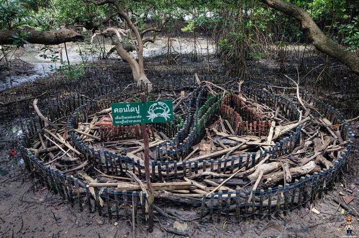
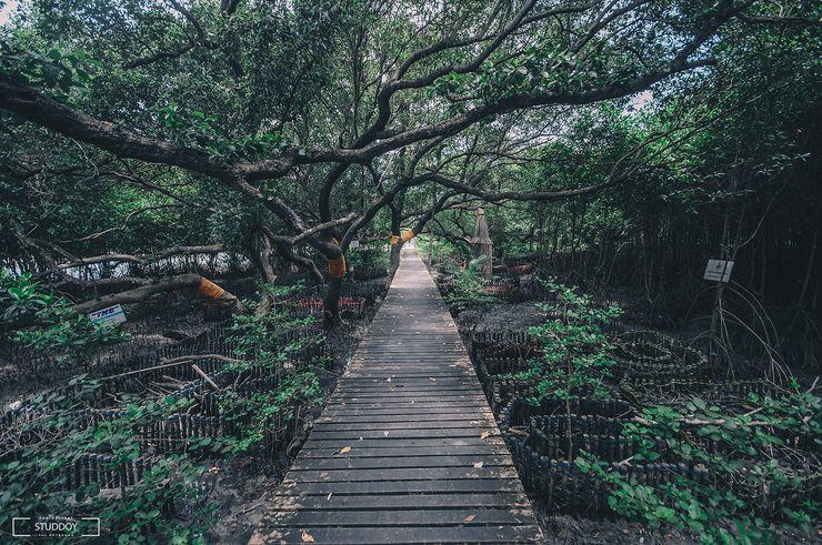
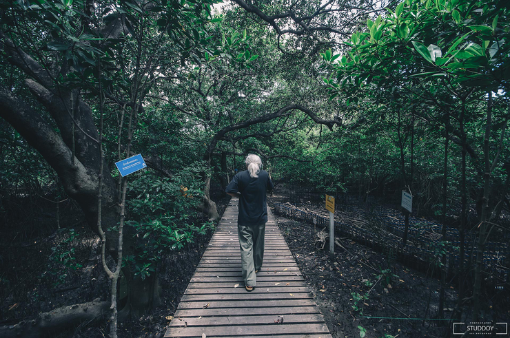
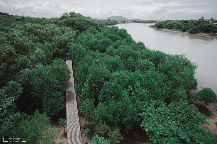
This site is a mangrove ecosystem learning center located at the mouth of the Rayong River, covering an area of over 500 rai and covered with mangrove vegetation. Along the nature trail, there are various trees, some of which are hundreds of years old and have large, spreading branches, creating a shady atmosphere. Most of the trees are species of the genera Rhizophora, Avicennia, Sonneratia, Bruguiera, and Lumnitzera. In addition, this area is a nursery for aquatic animals and a breeding ground for shellfish and crabs. The concept of creating "shellfish mounds" and "crab condos" is to provide a natural habitat and breeding ground for aquatic animals such as fiddler crabs, hermit crabs, sea crabs (black crabs), and various fish species, creating a complete ecosystem.


A Haven in the Mangroves: The Story of Uncle Sombun's Forest
Amidst the lush mangroves, a small wooden hut stands as a testament to the dedication of Uncle Sombun Suk-in. A sign bearing his story hangs proudly outside, recounting his remarkable journey.
Uncle Sombun, a fisherman since his youth, purchased this land when it was merely an open field. With unwavering determination, he began planting trees, one by one, over a period of four decades. His efforts eventually caught the attention of the government, leading to a collaborative reforestation project.
Through meticulous propagation and transplantation, Uncle Sombun transformed the barren land into a thriving ecosystem. Today, the once-empty field has become a haven for aquatic life, a testament to the power of individual action and the transformative potential of nature.


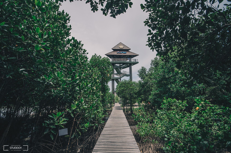
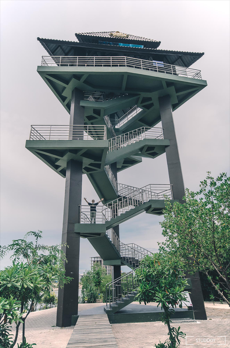
The end of the trail leads to the Chalermprakiet Observation Tower, which is built next to the Rayong River. The tower is a triangular structure with a height of 22 meters and a width of 8 meters. The nature trail from the entrance to the observation tower is 400 meters long. From the top, you can see the Rayong River flowing alongside Saeng Chan Beach and out to the mouth of the bay, with the distant Yaida Mountains in the background.


⏩ Phla Beach
- 🏠 Location: 36 Phla Road, Phla Subdistrict, Ban Chang District, Rayong 21130
- 📷 Coordinates: https://goo.gl/maps/ufmzzXiPk2...
- ⌚ Opening hours: Open 24 hours
The beach is located near U-Tapao Airport, adjacent to Phuyu Beach and Nam Rin Beach. It is characterized by rows of pine trees, creating a shady atmosphere. The beach is part of a fishing village community and is not suitable for swimming. However, it is an ideal spot for enjoying the sea breeze, dining at beachfront restaurants during sunset, or purchasing fresh seafood from local fishermen at affordable prices.


Hat Phayun - Hat Nam Rin
Location: Ban Chang Subdistrict, Ban Chang District, Rayong 21130
Coordinates: https://goo.gl/maps/fU4mudPP1zXaXi17A
Opening Hours: 24 hours
Note: This translation is based on the provided HTML structure and avoids personal pronouns, colloquialisms, and subjective opinions. It also adheres to a formal academic style and uses the active voice.
The two beaches are connected to Haad Pla. Haad Phayun is in the middle, followed by Haad Nam Rin, separated by the Mangkorn Bridge and the Luang Tie Shrine. Both beaches are quiet and suitable for swimming, with beautiful scenery. However, the significant problem is waste management, with a large amount of marine debris washing ashore. Additionally, abandoned structures detract from the aesthetics. If managed effectively, these beaches could resemble Bang Saen Beach. Historically, Haad Phayun and Haad Nam Rin were abundant with seagrass and served as a habitat for dugongs, hence the name Haad Phayun (Dugong Beach). However, dugongs no longer reside in this area.


Golden Rice Field
Location: Baan Saem Phu Community, Pak Nam Prasae, Klaeng District, Rayong Province 21170
Coordinates: https://goo.gl/maps/EY1pkxa9WSCjFdNG6
Entrance Fee: Free
Opening Hours: 6:00 AM - 6:00 PM
Another nature trail in the mangrove forest of Rayong is located in the Baan Saem Phu community, Pak Nam Prasae. It is a winding wooden bridge path that goes through the mangrove forest and ends at the Pak Nam Prasae community. The distance is about 2 km. From the parking lot, you can take a motorcycle sidecar to the entrance for 5 baht each. The parking fee is 20 baht. At the entrance, if you want to take a boat to see the scenery to the mouth of the river, there is a service for 50 baht each. It is recommended to take a boat first so that you can see the peaceful nature at the mouth of the river, as well as the small aquatic animals that live there and the fishing way of life of the local people.


After a short boat ride, we arrived at the Shrine of Father Saem Phu, a revered place of worship for the local community. According to legend, the shrine was originally a simple wooden structure with a single pillar. Villagers prayed for a bountiful fish catch, and their wish was granted. In gratitude, they constructed a new, permanent shrine that stands to this day.


From the Father Saem Bhoo Shrine, there is a path leading into the mangrove forest. Along both sides of the path, there are various species of mangrove trees, including Avicennia, Rhizophora, Bruguiera, Ceriops, and Lumnitzera. The area is also a nursery for aquatic animals that live in the mangrove forest, such as shrimp, shellfish, crabs, and fish.


A must-see highlight is the dense golden mangrove forest, which is a sight to behold after exiting the mangrove forest. This is a must-visit photo spot for tourists.


Royal Thai Navy Warship Prasae Memorial - Prasae Estuary
Location: Pak Nam Prasae Subdistrict, Klaeng District, Rayong 21110
Coordinates: https://goo.gl/maps/rFZwvdM44Bn748s78
Entrance Fee: Free
Opening Hours: 7:00 AM - 6:30 PM
The Prasae Warship Memorial was built to commemorate the Thai government's dispatch of the Prasae warship to fight in the Korean War under the United Nations. After performing maritime missions and protecting the country's sovereignty and maritime territory since 1951, it was decommissioned in 2000 and moved from Sattahip Naval Base to become a memorial on December 25, 2003. Today, the Prasae Warship Memorial has become an important symbol for tourists visiting the Pak Nam Prasae community, who can admire the size of the Prasae warship up close.


- Thank you to my friends who came to watch, like and share. It's encouraging.
- Exchange information or discuss travel information Fanpage: Studdoy Hundred Stories
- Follow old articles here All travel trips

สตั๊ดดอย ร้อยเรื่องราว
Wednesday, February 26, 2025 5:10 PM