


>> Follow our travel stories on Facebook at Hello Stranger Page.
https://www.facebook.com/hellostrangerpage/
>> IG: hellostrangerth
https://www.instagram.com/hellostrangerth
.
.
30 Places with Travel Records of Mountain Women
My name is "Koi". I started traveling solo and hiking seriously two years ago. I went to places I didn't know, I was scared, but that trip made me find good friendships from strangers.
A few years of travel have completely transformed our lives, pushing us beyond our limits and immersing us in the wilderness and mountains. We have embraced a simple way of life, shaped by experiences and friendships forged along the way. Looking back, every aspect of our journey brings us immense joy.

From that day until now…
We have had strangers as our travel companions.
We have had cameras as our companions to record memories.
We have had travel as our companion to open up the world.
And we have had the sky and mountains as our companions in the frame.
Driven by a desire to share our travel experiences and inspire others who may harbor fears about embarking on their own journeys of self-discovery and happiness, we aim to empower individuals to embrace the transformative power of exploration.
If you're ready, let's travel alone together.

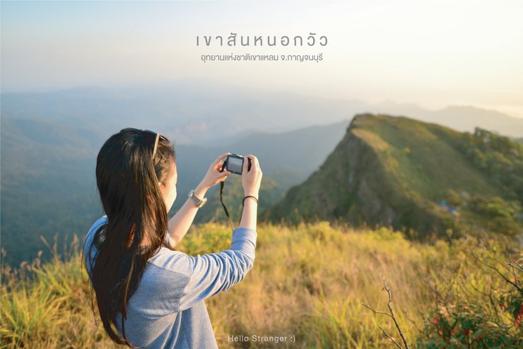
Khao San Nok Wua, Kanchanaburi
Khao San Nok Wua, located on the edge of the Thung Yai Naresuan Wildlife Sanctuary, is the highest peak in Kanchanaburi province. Situated within the Khao Laem National Park, it reaches an elevation of 1,767 meters above sea level.
The Journey to the Summit: A Hike Through the Wilderness
The journey begins with a car ride led by park rangers to the starting point of the hike, located near the base of Khao Huai Lon, not far from the park headquarters. From there, the ascent to the summit requires a guided trek on foot, with park rangers leading the way. The distance from the base to the campsite is approximately 9 kilometers (18 kilometers roundtrip), making it impossible to complete the journey in a single day. An overnight stay is necessary, with tents set up on the mountainside. The entire trek takes 2 days and 1 night. The highlights of the hike include the panoramic views from the ridges known as "San Nok Lek" and "San Nok Yai."
This was my first solo backpacking trip with strangers. I had no idea what to expect, but I had a wonderful time and made unforgettable friendships with my fellow travelers.
The sentence is already in English and does not require translation.

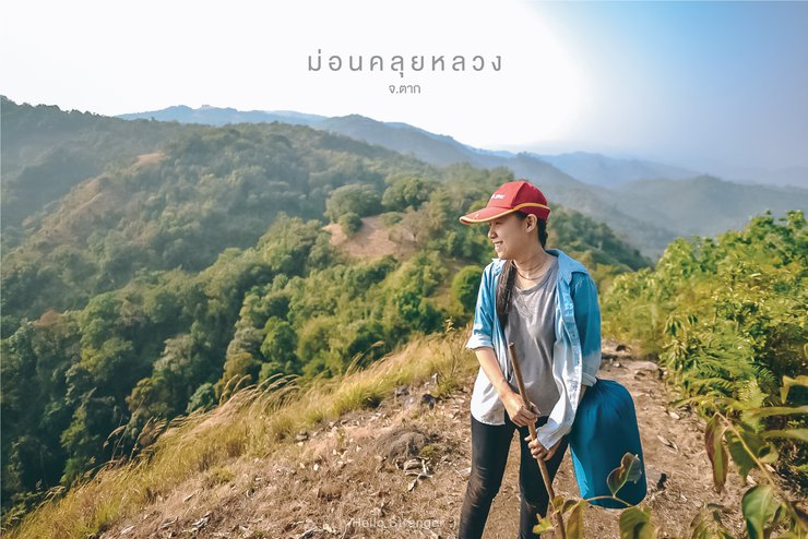
Doi Mon Kluy, Tak Province
Doi Mon Kluy, located in Tha Song Yang District, Tak Province, stands at an impressive 1,099 meters above sea level. Accessible by car, a 7.5-kilometer journey from the main road leads to breathtaking vistas of rolling golden grasslands and rugged mountains. The western viewpoint offers panoramic views of the Mae Nam Moei River, creating an ideal spot for camping and enjoying the sunrise.
No text provided for translation.

Doi Thu Le, Tak Province
Doi Thu Le is the highest mountain in Tha Song Yang District, Tak Province, with an elevation of 1,350 meters above sea level. The Pga K'nyaw people call this mountain "Thu Le Ko", which means "Golden Mountain". This name comes from the fact that during the winter months, from mid-November to January, the lush green meadows transform into a golden field amidst a sea of fog, accompanied by cool weather. This makes it an ideal location for camping, stargazing, and capturing stunning sunrises and sunsets.
Most visitors to Doi Thu Le are avid hikers who typically trek from Mon Kluay to Mon Thu Le, covering a distance of approximately 14 kilometers and taking 3 days and 2 nights.
This trip was a physically demanding one, with steep and challenging terrain. The heavy backpacks and an injured left knee made the journey arduous. Despite the difficulties, it was a memorable experience, forging friendships with over 20 strangers who shared the adventure through the wilderness.

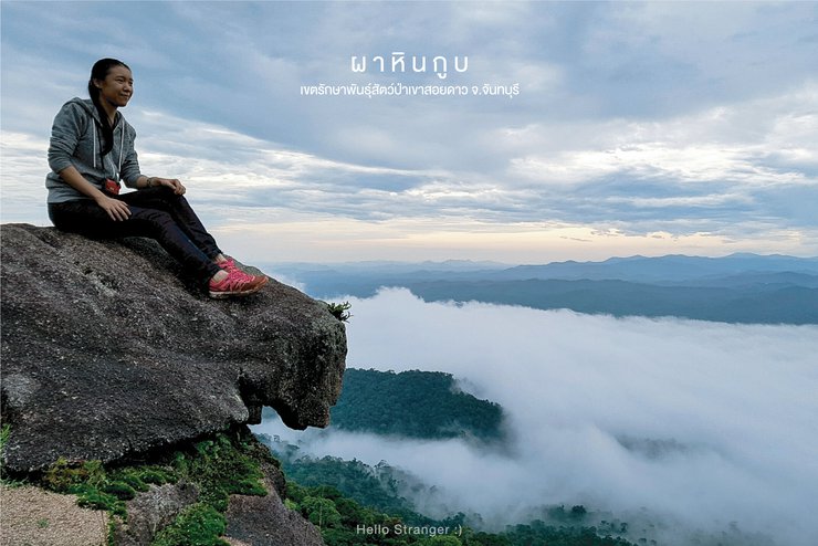
Khao Soi Dao Wildlife Sanctuary, Chanthaburi Province
The Khao Soi Dao Wildlife Sanctuary is located south of the Khao Soi Dao mountain range in Chanthaburi Province. The sanctuary is home to a variety of wildlife, including elephants, gibbons, and deer. Visitors can hike to the top of Khao Soi Dao, which offers stunning views of the surrounding area. The sanctuary is also a popular spot for birdwatching.
Key features:
- Located in Chanthaburi Province, Thailand
- Home to a variety of wildlife
- Offers stunning views of the surrounding area
- Popular spot for birdwatching
Additional information:
- The sanctuary is open to the public from 8:00 am to 4:00 pm daily.
- There is an entrance fee of 200 baht for adults and 100 baht for children.
- Visitors are advised to wear comfortable shoes and bring plenty of water.
Note: This translation is based on the provided text and does not include any additional information that may be available from other sources.
This trip was truly worthwhile, offering a diverse range of experiences. From trekking through rain and wading through water to climbing trees, braving thorny bushes, crawling through caves, riding elephants, sleeping under rocks, and witnessing a breathtaking sea of fog for the first time, this adventure had it all. Choosing to embark on this journey with five strangers was the right decision. Had I waited any longer, who knows when I would have finally gone. Thank you to all the amazing people who took care of me. I hope we can go on another adventure together soon.
Read more reviews of Khao Koo B on Readme.

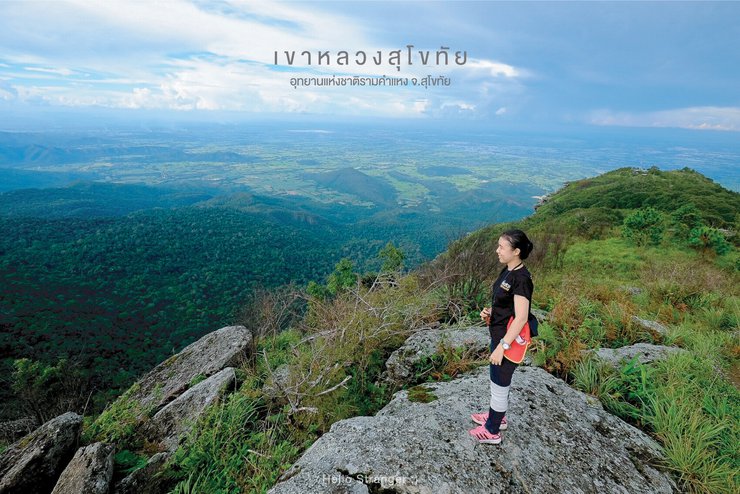
Khao Luang Sukhothai, Sukhothai Province
Khao Luang Sukhothai, located within Ramkhamhaeng National Park, is the highest peak in Sukhothai Province, reaching 1,200 meters above sea level. The trek from the starting point to the tent site at the summit is approximately 4 kilometers, a relatively short distance compared to other hikes. However, the steep incline makes it a physically demanding journey. Hikers often find themselves wondering when they will reach flat ground, as the steepness offers few opportunities for respite. Despite the challenging climb, those who reach the summit are rewarded with breathtaking views and a sense of accomplishment. However, when asked if they would repeat the experience, many respond with a hesitant "maybe," acknowledging the strenuous nature of the hike.
The site's notable features include a large banyan tree and four mountain peaks: Narai Peak, Phra Mae Ya Peak, Phu Ka, and Phra Chedi Peak.
This trip was our first time taking our younger sister hiking. The fun part was trying to take someone who is afraid of heights on a mountain trip, haha. But everything went well, and we were happy to meet an old friend from elementary school who, we later found out, also enjoys hiking and mountain trips like us... I hope we can go on another trip together, doctor. :)

Doi Mon Jong, Chiang Mai
Doi Mon Jong, located in Omkoi District, Chiang Mai Province, stands at an impressive 1,929 meters above sea level, ranking among the top 10 highest peaks in Thailand. The summit, known as "Head of the Lion," is accessible via a 16-kilometer off-road journey on a rugged dirt track followed by a 5-kilometer hike. The entire trek takes approximately two days and one night.
The main attractions are Phu Hin Chor, Pha Hua Singh, and the thousand-year-old rose (blooming from December to January. It is said that this thousand-year-old rose on Doi Mon Jong is the largest in Thailand).
Among the five most cherished travel destinations, Doi Mon Jong stands out for its captivating mountain scenery. Its beauty never ceases to amaze, and each visit brings a renewed sense of wonder. This trip also provided an opportunity to connect with fellow nature enthusiasts and strangers alike, fostering a sense of community and shared passion for the mountains. The experience served as a reminder of the power of nature to bring people together and create lasting bonds.
Read more reviews on Monjong at https://th.readme.me/p/13484

Mount Bak Dai, Loei Province
Mount Bak Dai is located within the Phu Luang Wildlife Sanctuary, Ban Klang, Phu Ruea District, Loei Province. It stands at an altitude of 1,200 meters above sea level. The hiking trail is approximately 3 kilometers long, offering a leisurely walk with scenic views, making it feel like a stroll through your own backyard.
For first-time hikers, Mount Bak Dai is an ideal starting point. The highlight is the "Deceptive Cliff," but the true charm of Mount Bak Dai lies beyond. We were particularly impressed by the ride on an "e-taek" (a modified motorcycle with a sidecar) through the local farmers' fields, offering breathtaking panoramic views. The stunning scenery prompted us to visit twice. During the rainy season, we encountered numerous snails, and the atmosphere was lush and green. On our second visit, the weather was cool and pleasant, and the mountains were painted in soft golden hues, creating a different kind of beauty.
Read more reviews of Phu Bak Dai here.

Doi Luang Chiang Dao, Chiang Mai
Doi Luang Chiang Dao, located in Chiang Mai Province, is home to the Chiang Dao Wildlife Sanctuary. Standing at 2,225 meters above sea level, this mountain is composed entirely of limestone and forms part of the Thanon Thong Chai mountain range. While there are two hiking trails, we opted for the Pang Wa-Ang Slung route, which covers approximately 6.5 kilometers. The initial section is quite steep and slippery due to recent rainfall, making the hike more challenging. However, once past the initial climb, the trail becomes easier, offering breathtaking 360-degree views. The stunning scenery made us forget our fatigue, allowing us to capture incredible photographs.
As night fell, the biting cold crept in, with temperatures plummeting to around -1 degree Celsius. The tent's roof was covered in frost, and the summit of Kiew Lom, where we were hoping to witness the sunrise, was shrouded in a thick sea of fog, obscuring the view and revealing only white-capped mountains. Although the conditions prevented us from capturing stunning photographs, the memories and camaraderie forged during this trip will remain vivid and beautiful forever.

Doi Pha Hom Pok, Chiang Mai
Doi Pha Hom Pok, located within Doi Pha Hom Pok National Park in Chiang Mai, stands at an impressive 2,285 meters above sea level, making it the second highest peak in Thailand. Reaching the summit requires a challenging hike, with a 3.5-kilometer trek from the campsite taking approximately two days and one night. While some describe the hike as relatively easy, the initial 30 minutes present a steep incline. However, the breathtaking panoramic views from the summit are well worth the effort.

Mokochu, Kamphaeng Phet Province
Mokochu is the highest peak in Mae Wong National Park, Kamphaeng Phet Province, with an elevation of 1,964 meters above sea level. Its name has been familiar to hikers since they first started exploring the trails. Many dream of conquering this peak at least once in their lifetime, as it is considered the ultimate challenge for Thai hikers, akin to earning a doctorate in the field.
We embarked on a five-day, four-night trek, covering a total distance of 64 kilometers on foot, in search of the Sail Rock. However, upon reaching our destination, we discovered that the Sail Rock itself held no particular significance. It was the journey and the experiences we had in the wilderness that left an unforgettable mark on us. The trek provided us with much more than just physical exhaustion. We overcame our initial fears and pushed beyond our perceived limits. The smiles, laughter, and camaraderie we shared created lasting memories that will forever be etched in our minds.
Read more reviews of MoGoJu here.

Phusoidao, Uttaradit
Phusoidao is located within the Phusoidao National Park in Uttaradit Province. The peak of Phusoidao stands at 2,102 meters above sea level, making it the fourth highest mountain in Thailand. The Larn Son (Pine Forest) area, part of Phusoidao, sits at 1,633 meters and requires a 6.5-kilometer hike, taking approximately two days and one night to reach.
The main attractions include the Dok Hong Naka flower field, Phusoidao Waterfall, Sai Thib Waterfall, and the Larn Son Pine Forest.
We have visited this location twice, and each time the beauty has been different. The first visit was particularly memorable due to the Dok Hong Naka flowers blooming across the entire field. The second visit, while not as spectacular, solidified our memories of Phusoidao. We believe that if we return for a third visit, we will finally reach the 2,102-meter peak.

Red Cliff of Lamphun
Red Cliff of Lamphun is a viewpoint located in Mae Ping National Park, Lamphun Province. Situated at an altitude of 1,000 meters, it offers stunning views of the Ping River and the Bhumibol Dam reservoir in the distance. Visitors can witness breathtaking sunrises from this vantage point.
Reaching the viewpoint requires a journey by park ranger vehicle from the campsite, followed by a 1-2 kilometer hike through the forest.
A Solo Adventure:
This particular trip was undertaken by a solo traveler who joined forces with two strangers. Together, they embarked on an unplanned adventure, exploring various tourist destinations in Lamphang, Lamphun, and Chiang Mai. Their journey involved hitchhiking, walking alongside roads, and even sleeping in the wilderness.
The traveler expresses gratitude to their companions for sharing the experience of hardship and the biting cold wind atop the mountain while riding in the back of a pickup truck. They hope to embark on similar adventures together in the future.

Kew Mae Pan, Chiang Mai
Kew Mae Pan is located within Doi Inthanon National Park in Chiang Mai Province. It is a short, circular nature trail of approximately 3 kilometers, situated at an elevation of around 2,000 meters above sea level. This scenic location offers breathtaking views of the sunrise and a mesmerizing sea of mist.
The highlights of this trip include the ancient rose bushes, the wooden balcony viewpoint, the small rock formations, and the Mae Kham Ning waterfall (during the winter season).
This trip is a continuation of the Pha Daeng Luang trip, and the fun doesn't stop there. We continued our adventure, carrying backpacks weighing around 12 kg, and hiked up to Kiew Mae Pan, which is not a common route. After reaching the top, we were rewarded with stunning mountain views and a sea of fog, making it a truly worthwhile experience.
Read more reviews of Kiew Mae Pan:

Pha Chanadai, Ubon Ratchathani
"Pha Chanadai" is a mountain with an altitude of approximately 450 meters above sea level. It is located in Pha Taem National Park, Khong Chiam District, Ubon Ratchathani Province. The cliff face is located at the easternmost point of Thailand. It is the starting point for calculating sunrise time and is the first place in Thailand to see the sunrise. Looking down, you will see the Mekong River, which forms the border between Thailand and Laos. To get there, you need to take a pickup truck or four-wheel drive vehicle along a rough road through a rocky area. The distance is about 20 kilometers. From the tent site, it is a 1-kilometer walk to Pha Chanadai cliff. The trip takes 2 days and 1 night.
This trip was a thrilling adventure from start to finish. Due to the remote location of our planned destination and the lack of public transportation, we had to hitchhike our way to Pha Charanadai. Fortunately, we encountered a group of people who were also heading there, and they kindly offered us a ride. We are incredibly grateful to these strangers for their generosity.
Read more reviews of Pha Charoen Dai at: https://th.readme.me/p/11168

Phu Kradueng National Park, Loei Province
Phu Kradueng National Park, located in Loei Province, Thailand, boasts an elevation of 1,316 meters above sea level. The trek from the starting point to the Wang Kwang Tourist Service Center covers approximately 9 kilometers, with an additional 30 kilometers of exploration across various points of interest. This journey typically takes 3 days and 2 nights. Notable attractions include Tham Yai Waterfall, Pha Ngern Waterfall, Sano Daeng Pond, Pha Lom Sak Cliff, Pha Nok Aean Cliff, and Pha Mak Doo Cliff.
This trip can be summed up in one word: incomplete. I will have to return to finish it, as I didn't reach the Pha Lom waterfall. This was due to an injury, but it wasn't a total loss. I set out to find maple leaves and was successful in doing so.
Read more reviews of Phu Kradueng here.

Doi Luang, Phayao Province
Doi Luang Phayao is located in Doi Luang Phayao National Park, Phayao Province. It has an altitude of 1,694 meters above sea level. There are several routes to the summit, both from Phayao and Lampang. The newest route is near Ban Mae Na Reu, with a distance of about 12 kilometers, which is quite far and difficult to walk. The regular route for tourists is near Ban Pak Bok, Lampang Province, which is on the border of Phayao and Lampang. It takes 2 days and 1 night.
Read more reviews of Doi Luang Phayao https://th.readme.me/p/11286
No text provided for translation.

Doi Nok, Phayao Province
Doi Nok is located in Doi Luang Phayao National Park, Phayao Province. It is situated below Doi Luang, approximately 4 kilometers away. Most tourists hike from Doi Luang to Doi Nok, which takes 3 days and 2 nights.
This trip was incredibly tiring but also incredibly rewarding. Although I didn't see the sea of mist or the sunrise and sunset, it was worth it because I conquered my own fears, braved the steep slopes and heights, and reached the summit of Doi Nok. I also paid my respects at the Doi Nok stupa and the Buddha's footprint, which are said to be a must-visit for anyone who comes here.
Read more reviews of Doi Nok at https://th.readme.me/p/11286

Doi Luang Tak, Tak Province
Doi Luang Tak is located in Tung Kra Sae Subdistrict, Ban Tak District, Tak Province. It has an altitude of 1,175 meters above sea level. The journey begins with a 6-kilometer pickup truck ride from the Tung Kra Sae Subdistrict Municipality to the starting point, followed by a 22-kilometer round-trip hike to the summit. The hike takes two days and one night. The highlights include the pine forest slope and the 360-degree panoramic view from the summit. Doi Luang Tak is an ideal destination for beginner hikers, offering a moderately challenging hike with stunning views.

Doi Phu Wae, Nan Province
Doi Phu Wae is located within the Doi Phu Kha National Park in the Chalermprakiet District of Nan Province. The peak of the mountain stands at 1,837 meters above sea level. The trek to the summit is approximately 8 kilometers and takes 2 days and 1 night.
Key highlights of the trek include:
- Sunrise viewpoint: Witness the breathtaking sunrise from the summit.
- 360-degree panoramic views: Enjoy stunning views of the surrounding landscape.
- Scenic cornfields: Hike through picturesque cornfields along the trail.
- Rural charm: Immerse yourself in the authentic rural atmosphere of the nearby villages.
Doi Phu Wae is a stunning location ideal for those who enjoy conquering mountain peaks. The hiking trail is challenging and steep in sections, but we still adore this place. The wonderful memories we made with our fellow travelers and the new friendships we formed here make it a truly special destination.
Read more reviews of Doi Phu Wae at https://th.readme.me/p/17510

Khao Luang, Prachuap Khiri Khan
Khao Luang is located in Namtok Huai Yang National Park, Prachuap Khiri Khan Province. It stands at an elevation of approximately 1,250 meters above sea level. The hike to the summit is approximately 7 kilometers and takes 2 days and 1 night. Notable features include the Huai Yang Waterfall and scenic viewpoints overlooking the coastline.
This trip was quite challenging. We walked in the rain, waded through water, and crossed steep paths along the way, which was full of dense trees. Known as "Khao Luang," it guarantees steepness. Khao Luang Prachuap is another place that challenges mountain climbers to fight against the steepness and survive the leech forest. No matter where you stand or walk, they are ready to attack and suck blood for food.
Although this trip didn't have many beautiful pictures because of the rain and cloudy sky, we got to experience the pristine forest, which is considered the first place where we didn't see any garbage along the way. We would like to ask everyone who comes to conquer the mountain here to help maintain cleanliness and beauty so that it remains like this forever.
Read more reviews of Khao Luang, Prachuap Khiri Khan here.

Doi Samer Dao, Nan Province
Doi Samer Dao is located in Si Nan National Park, Nan Province, at an altitude of 888 meters above sea level. The highlights are Pha Chu and Pha Hua Singh, popular spots for relaxation, camping, and stargazing. However, since we visited on a full moon day, we couldn't see any stars. Haha! But that's okay. This trip was a dream come true. We'll come back again next time.
Read more reviews of Doi Samer Dao at https://th.readme.me/p/11161

Takhian Ngoh Viewpoint: A Breathtaking Panorama of Khao Kho
Takhian Ngoh Viewpoint stands as one of the most stunning scenic spots on Khao Kho, offering a breathtaking 360-degree panorama of the surrounding landscape. Witness the mesmerizing spectacle of a sea of mist enveloping the mountains, while the golden hues of the rising sun paint the sky in vibrant colors.
From this vantage point, gaze upon the majestic silhouette of Khao Pu and Khao Ya mountains, their contours reminiscent of Mount Fuji. The verdant expanse of Khao Kho's forests unfolds before you, while winding roads snake their way towards the viewpoint, adding to the picturesque scene.
The sentence is already in English and does not require translation.

Khao Daeng, Prachuap Khiri Khan
Khao Daeng Viewpoint is located in Khao Daeng Village, Kui Buri District, Prachuap Khiri Khan Province. The village is situated next to a mountain with red cliffs, hence the name Khao Daeng (Red Mountain). Currently, it is part of Khao Sam Roi Yot National Park. To reach the viewpoint, visitors can travel approximately 400 meters north from the park headquarters and then hike up Khao Daeng for another 320 meters. The highlight of this location is the 360-degree panoramic view.
This trip was my first experience with backpacking and hitchhiking. I would like to express my gratitude to the kind strangers who gave me a ride to the park and to the staff of Khao Sam Roi Yot National Park for making this trip a success. Thank you very much.

Phu Thap Boek, Phetchabun Province
Phu Thap Boek is located in Wang Ban Subdistrict, Phetchabun Province, at an altitude of approximately 1,768 meters above sea level, making it the highest point in Phetchabun. It is a popular tourist destination known for its stunning views of the mist-covered mountains and cabbage fields.
On this solo trip, I met a fellow traveler, a woman named Kat, who also enjoys traveling alone. We bonded over our shared passion for adventure and exploration. Thank you, Kat, for taking these photos for me. I'm grateful for our encounter and hope to travel together again in the future.

The original text is empty. There is nothing to translate.
Khao Hin Pum, Phetchabun Province
Khao Hin Pum is a mountain peak with an elevation of 1,262 meters above sea level, located within the Phu Hin Rong Kla National Park. It features a cliff face with numerous knob-like rock formations of varying sizes, believed to be the result of natural erosion. The area offers a relaxing nature trail with scenic views and cool breezes along the way.

Pha Chu Thong, Phetchabun
Pha Chu Thong is a mountain peak with an elevation of 1,304 meters above sea level, located approximately 500 meters from Hin Pum Stone Field within the Phu Hin Rong Kla National Park. Characterized by its steep cliffs, the peak offers breathtaking panoramic views, particularly during sunset. A 1-kilometer walking trail leads to the summit.
This viewpoint left a lasting impression on us due to its stunning scenery and peaceful atmosphere, allowing for hours of relaxation and photography.

Pitulu Waterfall, Tak Province
Pitulu Waterfall, also known as Pitertolosoo Waterfall, is located in the Umphang Wildlife Sanctuary, Umphang District, Tak Province. It is the largest and highest waterfall in Thailand, with a height of over 500 meters. The waterfall is formed by two streams that flow down from Doi Mamuang Sam Wan and converge at a steep cliff, creating a heart-shaped cascade.
Reaching the waterfall requires a challenging hike through mountains and streams. The journey takes approximately 2-4 hours, depending on the hiker's pace, to reach the campsite. From there, it's another 2-hour trek to the waterfall itself.
Normally, hiking doesn't allow for showering, but this hike allows us to go to sleep feeling refreshed, as there is a waterfall not far from the campsite. I love it here. :)
Read more reviews of Pitukrok Waterfall here.

Samed Nang Chee, Phang Nga Province
"Samed Nang Chee Viewpoint" is a tourist attraction that is said to be one of the most beautiful sunrise viewpoints in Phang Nga Province. It is an easy trip, no need to hike, and you can still see the beautiful natural scenery that is no less than on the top of the mountain. Wake up early to catch the first light of the morning reflecting on the water's surface, as beautiful as heaven on earth.

The Bolaven Plateau, Lao PDR
The Bolaven Plateau is located in Dong Hua Sao National Park, Pakxong District, Champasak Province, Lao PDR. Our destination on this trip was Tad Khammouane Waterfall, which involved a challenging nighttime hike. The 5-kilometer trail led us through small and large streams, some with strong currents, where we opted to cross using a zipline. The rain-soaked trail turned muddy and slippery, making for a very wet and messy journey. We finally reached the campsite at almost 9 pm. The next morning, we set off for the waterfall, encountering a steep descent with small and large rocks that required climbing. After a 3.5-kilometer trek, we were rewarded with the magnificent sight of Tad Khammouane Waterfall.
This was my first international hiking trip, and it was an exciting and unforgettable experience. I encountered new challenges and learned valuable lessons about hiking in a foreign country. This trip will stay with me for a long time.

Whitewater Rafting on the Nan River, Thailand
This trip was a whitewater rafting adventure on the Nan River, renowned as the most challenging in Thailand. Spanning at least two days and one night, the journey covered over 120 kilometers. Unlike typical trekking expeditions, this trip focused on navigating the rapids while admiring the stunning mountainous scenery. The constant immersion in the river's flow offered a unique and exhilarating experience. Additionally, short hikes punctuated the rafting, creating a well-rounded adventure encompassing whitewater thrills, refreshing swims, invigorating hikes, and breathtaking mountain vistas. This trip ranks among my favorites, and I eagerly anticipate returning for another unforgettable experience.
Note: These 30 locations are just a fraction of the amazing places we visited.
Solo travel: a joy we create without waiting for anyone.
Let's go on a trip together alone.
Hello, stranger.
HelloStranger


สวัสดีคนแปลกหน้า
Wednesday, February 26, 2025 7:52 PM