


...When it comes to rainy season tourist destinations, there are probably many places that come to mind for our fellow travelers. I am the same, I have been planning since last year after Air Asia released the 0 baht pro "Book this life, fly next life" promotion. I booked it from the first day and chose to travel on weekdays to Nan province without knowing where I would go. At the beginning of this year, I started looking for tourist attractions in Nan province. It is surprising that this province has so many tourist attractions that it is enviable, even though it is a closed city. If you want to come here, you have to really intend to come because this province is not a passing city. Apart from "Doi Samer Dao" in Na Noi district, which is well-known, I think there are 2 more districts that people like to visit, which are Pua district and Bo Kluea district. This is the origin of following the green route of these 2 districts to see if it is as beautiful as its reputation. Let's follow me on this journey...
From the city to the forest
....The Airbus A320, flight FD 3556, took off from the capital's airspace at 3 pm, leaving behind the hustle and bustle of the city. Leaving the capital, I looked down at the Chao Phraya River from a height of 18,000 feet. After passing Nakhon Sawan, I looked down and saw a red river flowing through the plains at the foot of the mountains into a dam that I knew from above was the Sirikit Dam in Uttaradit Province. The letters on the dam's crest were very clear. I immediately understood that it must be the Nan River, and that I would soon arrive.

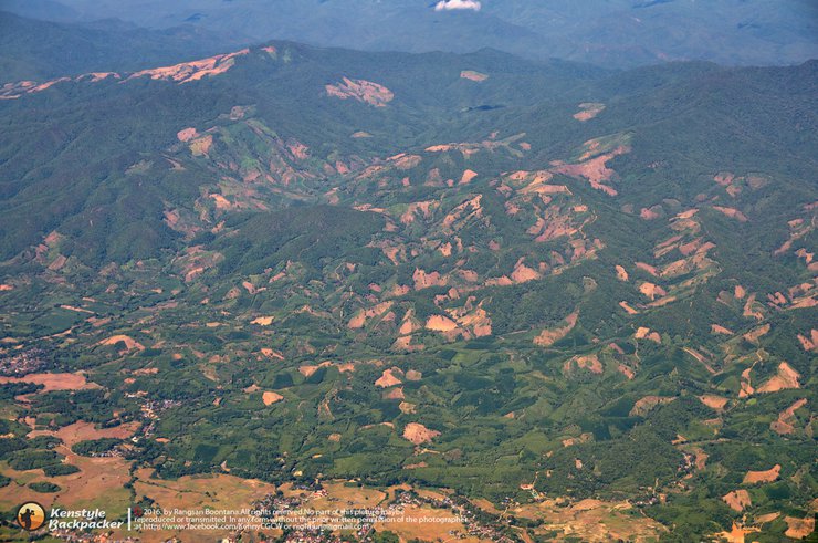
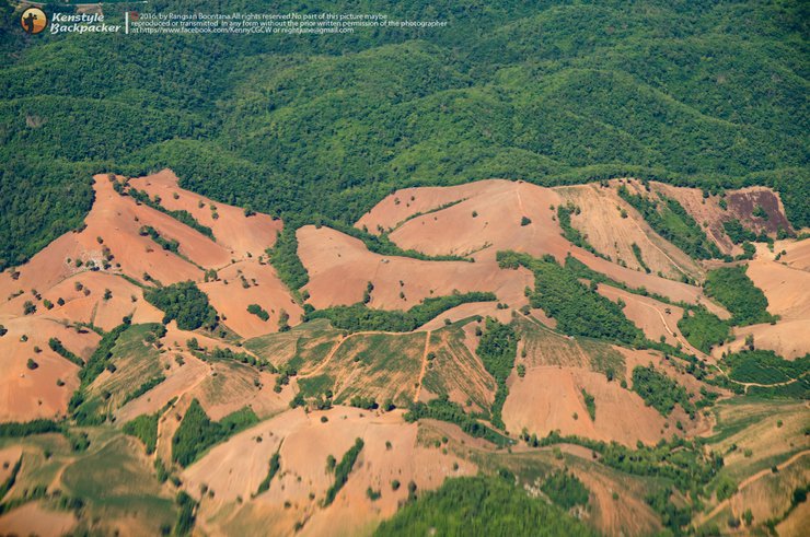
As I entered the sky above Nan province, I was met with the sight of mountains that had been stripped of their forest cover, leaving patches of bare earth that resembled a human head shaved with clippers. The deforestation was so extensive that it was impossible to miss, even from the air. It's hard to believe that those in power could claim ignorance of this situation, as it's not a recent phenomenon. This deforestation has been going on for 20-30 years. It's astonishing that despite long-standing forest conservation efforts, our forests continue to shrink. The consequences of this destruction are evident in the natural disasters that we, humans, have brought upon ourselves. Floods, landslides, and mudslides have become commonplace, and the news continues to report fresh incidents of flash floods after even brief periods of heavy rain.


Nan Nakhon Airport - Pua District
Upon arriving at Nan Nakhon Airport, I opted for a rental car from Avis, having purchased a voucher in advance at the Thai Travel Fair for 800 baht per day earlier in the year. This proved to be more economical than booking closer to the travel date. The rental car counter is conveniently located within the airport. The required documents for car rental included a driver's license and a credit card for a security deposit, which was authorized for 8,000 baht. Additional insurance options for accident and theft were available for an extra 170 baht per day each.

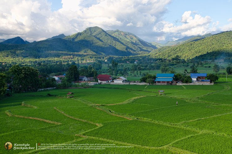
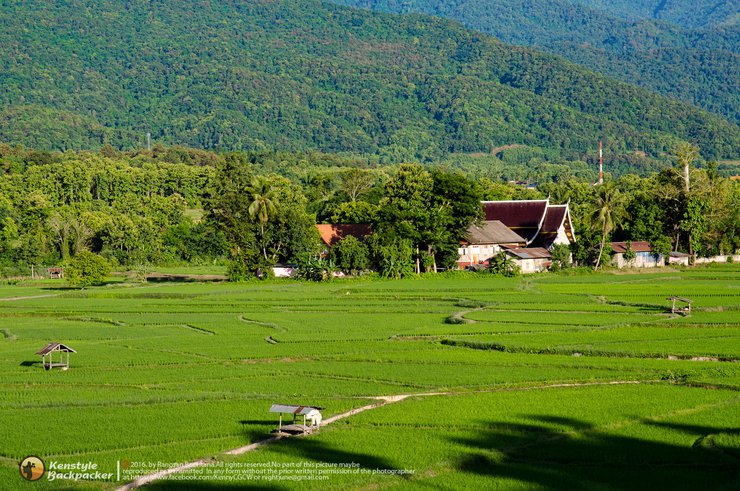
After picking up the car, I brought a Garmin car GPS with me just in case the GPS signal on my phone in Google Maps was weak. The first destination was Wat Phukhet in Pua District. I left around 4 pm and took Highway 1080 Nan - Thung Chang, a distance of about 62 km. The road in Tha Wang Pha district needs to be careful because there is road construction between km 27-40. If it rains, it will be muddy. On a sunny day, the dust will be everywhere. It took me almost 2 hours to reach the temple because I stopped to eat something along the way and, as expected, the mobile phone GPS signal was weak in some areas, so I mainly relied on the car GPS for navigation. After parking the car, I immediately walked straight to the front yard of the ordination hall behind the temple, which is the landmark of this temple. I chose to take pictures in the evening because this angle would be backlit if I took pictures in the morning. The sun will rise on this side. The view in front of me is a large green rice field with Doi Phu Kha National Park as a backdrop, looking beautiful. The rice plants are starting to grow after a month of transplanting. The peak season here is September-October when the rice plants turn golden yellow and are ready for harvest.


After taking some photos, I had to continue my journey to the accommodation because, judging from the reviews, the road to the accommodation at night is quite dark. The most popular accommodation in Pua district is Tanong Homestay. In fact, there are many other accommodations in Pua, but when I read the reviews, I mostly found Tanong Homestay, so I wanted to know what it was like. Is it as beautiful as the reviews say? Let's go see. I couldn't find the way to Baan Tanong on my Garmin GPS, so I relied on Google Maps instead. I'm sure you'll find it. Drive according to the GPS directions. If you see the condition of the road leading to the rice fields where cars can cut through, don't be surprised or worried. You're on the right track. The road will wind its way through the rice fields. The road is a narrow dirt road. Be careful when passing each other, or you'll end up soaking in the rice fields. It was already dark when I arrived. I parked my car and was greeted by an old man and woman. The old man must be Tanong, and the woman must be Tanong's wife. Or maybe not, I didn't ask her name. Haha. I booked a room in the Country House on the 2nd floor for 500 baht. When I arrived at the room, I took a shower first. Then I lay down and listened to the sounds of nature at night. The frogs, toads, cicadas, crickets, and other nocturnal insects sang in unison. I don't know when I fell asleep, but I woke up with a start at dawn when it started to rain. The sun began to peek over the horizon, casting a golden light. I quickly got up, washed my face, and prepared my camera equipment to capture the sunrise of the new day.
Tanong Homestay
..Tanong Homestay is located in Ban Don Sathan, Pua District. If you are driving yourself, please get off at Pua Market and then take a motorcycle taxi to get there. If you are driving yourself, you can follow Google Maps. For more information, please visit Tanong Homestay.


It's time to explore the place. Let's take a look at the atmosphere both inside and outside the accommodation. In the picture you see is the Heuan Country, where I stayed is a 3-story wooden house. The top floor has only one room with a balcony on one side facing east. The 2nd floor where I stayed has 2 rooms and 2 balconies, one facing north and the other facing east. The interior of the room is simply decorated. The floral curtains blend in with the color tone of the room, giving a warm and relaxing feeling. The room only has air conditioning and a TV. The bathroom has a hot water heater. The refrigerator is a shared refrigerator placed on the 2nd floor balcony. One piece of advice is not to leave the bathroom light on at night, as there are many small insects that fly through the vents to play with the light. When you wake up to use the bathroom, you might be surprised at how many there are. The downstairs area is a kitchen for cooking, with free gas. Plates, bowls, and spoons can be picked up and washed there.


Let's take a look at the scenic views around the house. The mist flows gently, covering the mountains in front of the house. The rice fields are starting to sprout, and the view is lush and green everywhere.


The villagers of Ban Don Sathan's way of life begins anew each morning. Although new structures have been built to accommodate the growing number of nature-loving tourists, the villagers' way of life remains unchanged.


This morning, I actually intended to go back to Wat Phukhao Thong to capture the sunrise again, but I had to change my plans because it rained near dawn. So I had time to walk around the rice fields near my accommodation in the early morning. It's good to live a life without rushing, but I can never do it as I wish because the travel program I set is always stuck in my mind. The best way to relax for me is to travel... So when I thought about it, I packed my bags and checked out to my next destination, "Doi Sakad". But unfortunately, the GPS gave me the wrong location, and I drove about 20 km to Chiang Klang District. I was wondering why I couldn't reach it because I had previously studied the travel information from Ban Don, which is about 20 km from the mountain. I searched again in Chiang Klang District and it said it was another 30 km away, which is the way to Thung Chang District. If I drive back and forth from Pua, wouldn't it be 100 km? So I changed my mind because I planned to come back to visit the famous temples in Pua District again. On the way, I stopped by to visit a temple in Chiang Klang District. I saw a sign saying that Wat Phra That Chom Kitti was not far away, so I stopped by to pay my respects to the pagoda.
Wat Phra That Chom Kitti
Located in Ban Pa Lao, Tambon Phra Phutthabat, Amphoe Chiang Klang, from Pua, head towards the road on the Pua-Chiang Klang-Thung Chang route. When you reach Amphoe Chiang Klang, there is a left turn with a sign indicating the way to the temple. Drive for another 8 kilometers. The temple is located on a mountain behind the village. There is a Buddha statue facing Doi Phu Kha. The stupa, which contains the Buddha's hair relics, is located on another nearby hill. There is a clear view of the Ban Pa Lao village.


Wat Nong Daeng
After leaving Wat Phra That Chom Kitti, I checked my GPS and saw another famous temple in the district nearby, so I took a detour through the village. This temple is also located on the same road as Wat Phra That Chom Kitti. It is an ancient temple of Nong Daeng village, built over 200 years ago by the Tai Lue and Tai Yuan people. Inside the viharn, the principal Buddha image is enshrined on a naga throne. Behind the temple is an ancient bodhi tree that is 1,700 years old. This bodhi tree even won first place in the provincial ancient bodhi tree contest. I don't know how they determined the age of the bodhi tree, but it seems to be much older than the temple, which was built over a thousand years ago. Moreover, the area around the bodhi tree is said to be the burial place of the treasure of a king of the Nanzhao Kingdom. After listening to the stories of the history and miracles from the abbot who came to greet me, I could only understand about this much, because I couldn't understand some of the northern words. He was very happy to see tourists driving in to see the temple. He told me that the temple does not need kathin or forest offerings, but would like to invite people to visit, learn about the customs and traditions of the Tai Lue people, and help spread the word. I would like to express my gratitude to him for showing me around the temple and telling me so many stories.


Leaving the temple, the next destination was to go back to Pua town again to capture images of several other famous temples in the district. Returning to Wat Phra That Kaew again to capture the full view of the rice fields in the late morning and take another picture of the temple.
Phuket Temple
Located in Ban Get, Woranakhorn Subdistrict, Pua District. You can find the directions on Google Maps. The temple is located on a hill in Ban Get Subdistrict, so the locals call it Wat Phu Get for convenience. The ordination hall is in the Lanna style with a principal Buddha image named Luang Pho Saen Pua or Luang Pho Phra Phuttha Metta. The highlight of this temple is the magnificent view of the rice fields behind the temple. At first, I wondered why all the temples faced Doi Phu Kha. Is there some trick to it? But then I realized that it's the east direction. This temple also offers accommodation services, called templestay. The rooms are well-equipped, not much different from a small hotel, with TV, Wifi, and air conditioning.


A view of the rice fields behind the temple, taking in the full beauty.


It was past one o'clock when I left the Phuket temple. For food, I won't focus on reviewing famous restaurants as much as I will on simple, single-dish meals. My next goal, following the footsteps of other reviewers, is of course, to find a beautiful, atmospheric cafe with a view. The famous one in Pua is
Baan Tai Lue Fresh Coffee Shop
This shop is located in Sila Lang Subdistrict, Pua District. There are people coming and going all day long, as you can see from the cars coming and going. Behind the shop, there is a walkway built over the rice field bunds, and there are cool photo spots along the path. The path also connects to the Lam Duan weaving shop next door. Coffee costs 40 baht a cup. After ordering, I walked to lie down in the hut. The coffee in this shop makes you want to sleep after drinking it, not because the coffee is not strong, but because the view of the rice field has a gentle breeze blowing from time to time. It's so dreamy.


Farmstay Baan Huanaam
Leaving the Baan Tai Lue coffee shop, I headed to another famous restaurant on the same road, just a few kilometers away. I wasn't interested in the food at this restaurant, but rather the view. However, I didn't want to just take pictures, so I ordered a single dish. Since this is a mushroom farm, most of the menu items are mushroom-based. I ordered a plate of stir-fried pork with basil and mushrooms. The taste was unexpected - it was really delicious, especially the pork, which was marinated to perfection. While waiting for my food, I walked around looking for photo opportunities. There is another unseen place nearby, Wang Sila Laeng, but it wasn't far away. However, I didn't have enough time, so I had to cut it from my itinerary. In addition to being a mushroom farm and restaurant, this place also offers homestay accommodation.


Pua - Bo Kluea - Span
At three o'clock in the afternoon, as I drove out of the mushroom farm, I had only managed to capture a few images of tourist attractions in Pua. I had to change my plan to capture other places because time was running out and the weather was starting to get cloudy. I didn't want to drive across Doi Phu Kha while it was raining because I didn't know what the road conditions were like ahead. Before I came, I heard that there was a landslide on the Pua - Bo Kluea road, which was the route we were going to take. So I set the GPS to change the route to Bo Kluea district, running on Highway 1256 that cuts up Doi Phu Kha. The road was well-paved asphalt, winding along the mountain ridges, going up and down the hills, I don't know how many hills. The route we took had points where there were landslides, trees were broken down, and there were hardly any cars passing each other along the way. There were only some cars from the Electricity Authority and the Highway Department that came to clear the road. The higher we went, the more we could see the scenery on both sides of the road, which were rice fields and cornfields that covered the mountainsides.


Doi Phu Kha National Park
Anyway, I had to pass through the park, so I stopped by the park's sea mist viewpoint for a bit. It's right by the road. The number 1715 is the elevation above sea level. During the winter, the fog would probably fill the entire valley. During this period, the park will be closed from July 1st to September 30th. Camping and overnight stays in the park are prohibited, and tourist activities in the park area will be suspended. However, the park's bungalows are still available for rent all year round.


Salt Lake View Resort
After driving over Doi Phu Kha, we entered the Bo Kluea district. Initially, we wanted to stop by the famous Bo Kluea salt mine, but it was closed during the Buddhist Lent period, according to local beliefs. Instead, we decided to buy some food to eat at our accommodation for the night. We spotted a restaurant with a beautiful view in Bo Kluea, located at the foot of a concrete bridge over a stream. The restaurant, called Bo Kluea View, was situated on a hillside. After ordering our food, we walked to the balcony to admire the view. Looking down, we saw the small, Ovaltine-colored Maeng stream flowing over rocks. Nearby, there was a guesthouse called Heuan Him Maeng, but it seemed deserted. We weren't sure if it was finished or not. We had read that this used to be the famous Aun Ai Maeng Bo Kluea guesthouse, but it had been sold and a new one had been opened in the village of Span, 8 kilometers away. This new guesthouse was where we would be staying that night.


Warmth of the Mangosteen at N. Span
From the 1256 Pua - Bo Kluea road that we crossed over Doi Phu Kha, we will meet the 1081 Santisuk - Bo Kluea road at the Bo Kluea intersection just after the concrete bridge. On the left hand side, you will go to Chalermprakiet district and Khun Nan National Park. On the right hand side, you will go to Phu Fa Development Center and Bo Kluea Mountain (whether left or right, the road is under construction, please be careful of the machinery working). Turn left towards Khun Nan National Park for about 8 kilometers, there will be a right turn into Ban Span village. Drive for another 2-3 kilometers and you will reach Aun I Mang Na Span. I arrived just as it was getting dark, so I didn't take any pictures of the room. In the morning, I remembered to look at the condition of the room and decided it was better not to take any pictures. 55 Yesterday when I arrived, the electricity was out. I think it was because of the storm that broke a tree and knocked down the power lines on the way here. But after about an hour, it came back. The next morning, the water was not flowing and the electricity went out again. It was quite a hassle. There was an uncle and an aunt who seemed to be taking care of the place. They were the only two people there. The uncle solved the problem by fetching water from the stream for us to use first. The aunt went to prepare breakfast for us. While waiting for breakfast, I walked around the homestay where I was staying. For details on the price of accommodation, please visit this link: Aun I Mang Na Span
The homestay has four rooms, three of which are teepee-style rooms built on stilts extending out over the water. The other room is a house that can sleep four people. There is a dining room that serves as the central common area, and the view from the dining room is the most beautiful. The back of the dining room is next to the Wa River, which is cloudy brown because it is the rainy season. The water will be red. If it is the winter season, the water will be clear. The bamboo bridge that I saw in the review has disappeared with the flood a few days ago. The mountain range is covered in fog because of the high humidity.


Inside the restaurant, the decor is warm and inviting. Breakfast consists of riceberry porridge, grown by the local villagers, served with fried eggs and sausages. For dessert, there are traditional Thai sweets. The housekeeper runs out to buy from the food truck that comes to the village every morning.


After finishing lunch, we hurried to continue our journey, as we had to visit several more places before our flight at 4:30 PM. Initially, we planned to visit the rice terraces at Ban Sawa, Ban Waer, but we were worried about the road conditions and the possibility of not making it on time, so we had to change our plans. We tried our luck by driving into Ban Span village. After driving for about 20 meters, we reached the entrance to the village. However, we decided to check out the sign that said "To Ban Huai Mi - Huai Thon" first, as it looked like a path leading up a hill, which would likely offer some good aerial views. We turned and crossed a bridge, and the road started to become a dirt track. We drove up a hill for a while, and the road conditions made us worry that we wouldn't be able to continue. However, the view along the way was stunning. We parked the car and took some photos, then tried walking up the hill a bit further. We stumbled upon a beautiful rice terrace, which was quite a sight. We figured that if we had driven into Ban Huai Mi - Huai Thon village, we would have seen more, but we were discouraged by the road conditions. If we have the chance, we will definitely come back and try again.


Heading back the way we came, we took a detour to enjoy a bird's-eye view of the village. We noticed a path leading up the mountain after standing at the spot where we took pictures of the rice terraces. The path to the high vantage point of the village is just a short drive past the Span Waterfall, and then a right turn at the school. It's a mandatory turn, and the road is quite steep, similar to Mon Cham, but the route is shorter and you'll reach the top in no time. There's a further path leading to Ban Pa Ko, but it's a dirt road. However, this isn't the highest point. There's a path leading up to a temple at the very top, but I think this is high enough. The farming here is characterized by paddy fields on the foothills, which don't cover a large area. In some places, the fields have to follow the slope of the mountain, hence the terraces, as there isn't enough flat land. The shape of the rice paddies is also unique, forming blocks rather than the rectangles seen in other regions.


Khun Nan National Park
After leaving Ban Span, I retraced my steps and stopped by Khun Nan National Park, which wasn't too far away and was also on my way back. I went into the park and asked if there were any viewpoints. The park ranger said there was one, but it was a 3 km walk, so I turned around and went back to my car. I saw a sign for Khun Nan National Park and a pavilion jutting out, so I thought I would have a great view. But the trees were blocking everything. I guess the trees weren't as big when they built the pavilion as a viewpoint.


Salt Well - Santisuk - Nan Nakhon Airport
On the way back to Nan city, I took Route 1081, Bo Kluea - Santisuk, which is said to be a sky road with exceptional beauty during sunset. However, I couldn't wait to see it because I would have missed my flight. From the Bo Kluea intersection, I drove straight towards Santisuk district. The view on both sides of the road was as people said, but it was a beauty that came at the expense of the destruction of the forest area. If there were forests, we might not see this kind of view... Most of the land on both sides of the road is planted with corn rather than in this zone.


Khao Soi Ton Nam Restaurant
Arriving in Nan city center at 12:30, I had about 3 hours to spare to capture the temples in the city. But first, I needed to find something to fill my stomach. I was recommended a simple local restaurant called Khao Soi Ton Nam, a small shophouse near the city pillar. There were 4-5 tables available. If there's no parking on the side of the road, I suggest parking inside the city pillar shrine, which is just a few meters away. I ordered two dishes: Khao Soi, a signature northern Thai dish, and Khao Moo Daeng (red pork with rice). I didn't expect much in terms of taste, as I've had Khao Soi in Bangkok before. But the first bite made me realize the true taste of Khao Soi - this is how it should be. The ones I had in Bangkok malls were generally sweet and greasy, but this one had a perfectly balanced and authentic flavor. The Khao Moo Daeng was also excellent. The sauce wasn't overly sweet, and the pork was thick and incredibly tender.


Ming Muang Temple - City Pillar Shrine
After a satisfying meal, it was time to continue exploring the temples. With about 2 hours left, I decided to prioritize the temples I wanted to visit most, even if they were located close to each other. The first temple I visited was Wat Ming Mueang. I felt that if I came to Nan and didn't pay respects at the city pillar shrine for good luck, it would be like visiting someone's home without greeting them. Wat Ming Mueang and the city pillar shrine are located in the same area on Suriyapong Road. It houses the city pillar of Nan province. The history of Wat Ming Mueang is as follows: It was originally an abandoned temple with a large city pillar, two people wide, found in the ruins of the viharn. Around the year 2400, Chao Anantaworaritthidet, the ruler of Nan, established a new temple and named it Wat Ming Mueang after the city pillar, which was called Sao Ming Mueang. Later, in 1984, the old ubosot was demolished and a new one was built in the contemporary Lanna style, which is still standing today. For more information about the history of the temple, please visit this link: History of Wat Ming Mueang


Phumin Temple
This temple is another famous temple in Nan province, located about 200 meters from Wat Ming Mueang, but on a different street. The murals of this temple are arguably more famous than the principal Buddha image in the viharn. This temple is none other than Wat Phumin, and the murals in question are the world-renowned "Whispering Love" paintings by Nan Bua Phan, a local Tai Lue artist. The paintings depict Pu Man and Ya Man, a loving couple, whispering something to each other. Professor Somchai Vimolkesem has composed a poem about the whispers, which reads:
"The love I have for you, my little sister, I would put it in the water, but I'm afraid it would be cold. I would put it in the open air, but I'm afraid the fog would come down and cover it up. I would put it in the palace, but I'm afraid the king would see it and take it away. So I'll keep it in my heart, where it can cry and sing to you, whether I'm asleep or awake."


Phra That Chae Haeng Temple
This temple is another important temple in Nan province, located about 3-4 kilometers from Wat Phumin. It is the zodiac stupa for people born in the year of the rabbit, located in Muang Ti, Phu Pieng district, 2 kilometers from Nan city center, which was the center of the old Nan city. The dried stupa is an important religious site that is over 600 years old. The dried stupa is the zodiac stupa for the year of the rabbit. Lanna people believe that if they travel to "chutha" or worship the stupa of the year of birth, they will receive great merit.
For the history of the temple, please refer to this link History of Wat Phra That Chae Haeng


Wat Phra That Khao Noi
After driving out of town, we drove back into town again, which is in the opposite direction of Wat Phra That Chae Haeng, which is Wat Phra That Khao Noi. We hurried to make time and it was the last temple we visited because we had about half an hour left. This temple is considered an important highlight. It is located at the front of the Buddha statue that overlooks the entire city of Nan. Anyone who comes to Nan must check in at this landmark to take a souvenir photo here. For the history of the temple, you can read it at this link. History of Wat Phra That Khao Noi


...In the end, we managed to check in just in time. This trip was really tiring with all the traveling to different places within 3 days and 2 nights. We couldn't cover everything we planned because there are so many tourist attractions in Nan. I think I'll find a chance to come back and experience the "Nan slow life" many more times. Because now I'm completely head over heels in love with Nan.
- Thank you to all my friends who came to watch.
-Thank you for the information about tourist attractions in Nan province from the pages Charm Nan Today This is Nan City
-Details of the route, accommodation Travel information, hotels, accommodation, car rental
-Exchange information or ask for travel information at Fanpage: Studdoy Hundred Stories
- Follow old articles here All travel trips


สตั๊ดดอย ร้อยเรื่องราว
Friday, September 27, 2024 10:20 AM